Early in 1811, Tecumseh, Chief of the Shawnees, warned reluctant warrior-tribes that he would stamp his feet and bring down their houses if they didn’t join him in an effort to drive the white man out of Indian territories. While the causality is dubious, one of the most violent and destructive earthquake tremors in the recorded history of North America shook the Mississippi River Valley shortly after, between December 16, 1811 and late April 1812. Over 2,000 tremors occurred during those four months, and geologists estimate that at least three of them were between 7.5 and 8.8 on today’s Richter Scale.
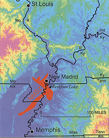
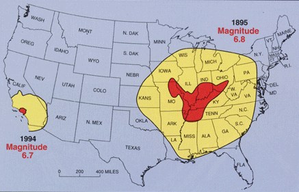
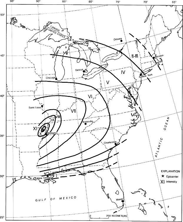
“This sequence of three very large earthquakes is usually referred to as the New Madrid earthquakes, after the Missouri town that was the largest settlement on the Mississippi River between St. Louis, Missouri and Natchez, Mississippi. On the basis of the large area of damage (600,000 square kilometers), the widespread area of perceptibility (5,000,000 square kilometers), and the complex physiographic changes that occurred, the New Madrid earthquakes of 1811-1812 rank as some of the largest in the United States since its settlement by Europeans. They were by far the largest east of the Rocky Mountains in the U.S. and Canada. The area of strong shaking associated with these shocks is two to three times as large as that of the 1964 Alaska earthquake and 10 times as large as that of the 1906 San Francisco earthquake” (USGS: Historic Earthquakes).
The New Madrid earthquakes were felt as far away as Canada and the eastern seaboard, the tremors caused church bells to ring in Boston and Philadelphia, the earth’s surface remained in a state of constant motion for nearly four months, several towns were destroyed, an 18 by 5 mile lake was created (Reelfoot Lake in Tennessee), and it appeared that the Mississippi River temporarily ran backwards. Eliza Bryan in New Madrid, Territory of Missouri, wrote the following eyewitness account in 1816:
“On the 16th of December, 1811, about two o’clock, A.M., we were visited by a violent shock of an earthquake, accompanied by a very awful noise resembling loud but distant thunder, but more hoarse and vibrating, which was followed in a few minutes by the complete saturation of the atmosphere, with sulphurious vapor, causing total darkness. The screams of the affrighted inhabitants running to and fro, not knowing where to go, or what to do – the cries of the fowls and beasts of every species – the cracking of trees falling, and the roaring of the Mississippi – the current of which was retrograde for a few minutes, owing as is supposed, to an irruption in its bed — formed a scene truly horrible” (source).
“The zone remains active today. In recent decades, minor earthquakes have continued. New forecasts estimate a 7 to 10 percent chance, in the next 50 years, of a repeat of a major earthquake like those that occurred in 1811-1812, which likely had magnitudes of between 7.5 and 8.0. There is a 25 to 40 percent chance, in a 50-year time span, of a magnitude 6.0 or greater earthquake. In a report filed in November 2008, The U.S. Federal Emergency Management Agency warned that a serious earthquake in the New Madrid Seismic Zone could result in ‘the highest economic losses due to a natural disaster in the United States’…The potential for the recurrence of large earthquakes and their impact today on densely populated cities in and around the seismic zone has prompted research devoted to understanding in the New Madrid Seismic Zone. By studying evidence of past quakes and closely monitoring ground motion and current earthquake activity, scientists attempt to understand their causes and recurrence intervals” (Wikipedia).
Article by Bill Norrington