According to a USGS news article, “Monitoring wildlife in the Arctic is difficult. Study areas are cold, barren, and often inaccessible. For decades, scientists have struggled to study animals, like polar bears, which live in these remote areas. Now researchers at the U.S. Geological Survey have begun testing a new, yet counterintuitive solution – rather then get close to the animals, monitor them from afar. Scientists have started using satellites to observe, count, and track polar bears. USGS scientists and their Canadian collaborators have begun analyzing high-resolution satellite images from a part of the Canadian High Arctic to determine the feasibility of using satellites to study polar bear populations.
“We tested the use of satellite technology from DigitalGlobe to count polar bears by tasking the satellite to collect photos from an area where we were also conducting aerial surveys,” said Dr. Todd Atwood, research leader for the USGS Polar Bear Research Program. “We then analyzed the satellite and aerial survey data separately and found that the abundance estimates were remarkably similar.”
The study, which is led by former USGS scientist and current University of Minnesota researcher Dr. Seth Stapleton, is part of an ongoing effort to identify non-invasive technologies to better understand how polar bears respond to the loss of sea ice due to a warming climate. This study tries to determine the number of polar bears and where they reside on Rowley Island in Nunavut’s Foxe Basin during the ice-free summer. “We selected Rowley as our study site because bear density is high during summer and the flat terrain provides an ideal setting to evaluate the use of satellite imagery,” said Stapleton.
Traditionally, scientists study polar bears by capturing and tagging them or by conducting aerial surveys with low flying aircraft. While these methods provide a wealth of important information, they are disruptive to the animals and are often not possible when dealing with remote locations. “We think satellite technology has the potential to open vast, remote regions of the Arctic to regular monitoring. It has tremendous potential to aid the circumpolar management of polar bears,” said Stapleton.
The next steps in the research focus on testing the satellites’ ability to detect polar bear populations over larger areas, including sites along coastal Alaska. Using satellite imagery shows incredible promise and provides one more tool for those interested in preserving polar bear populations for future generations. The ongoing research is part of the USGS Changing Arctic Ecosystems Initiative. The findings from the study are in the most recent issue of PLos ONE.
Abstract of the PLos ONE article (Stapleton S, LaRue M, Lecomte N, Atkinson S, Garshelis D, et al. Polar Bears from Space: Assessing Satellite Imagery as a Tool to Track Arctic Wildlife. PLoS ONE, 2014 DOI: 10.1371/journal.pone.0101513):
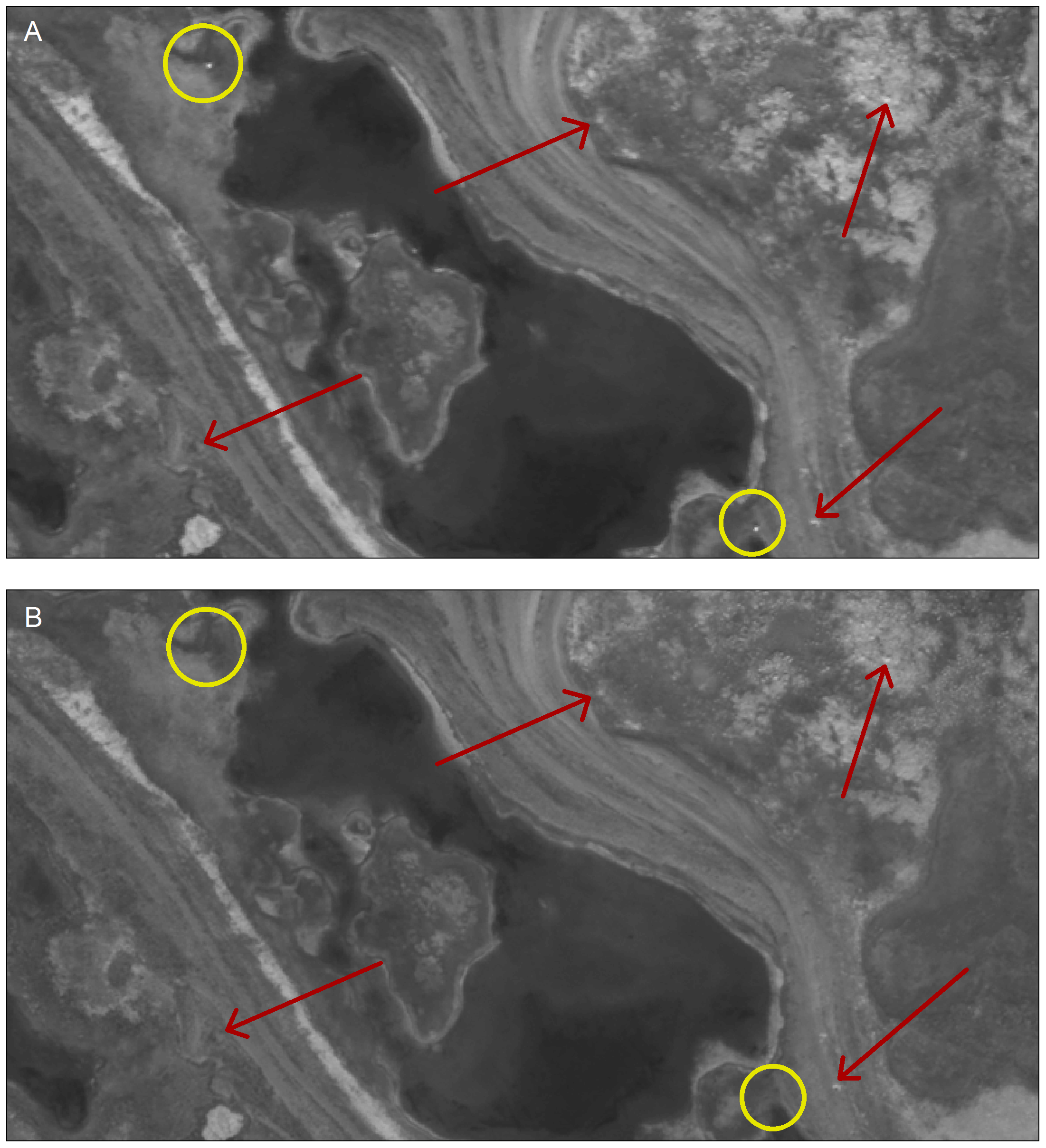
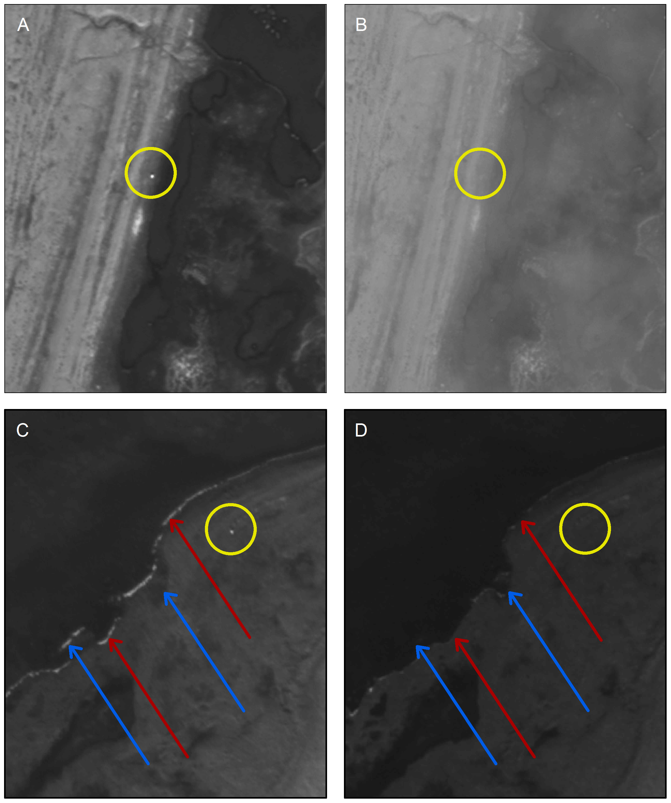
“Development of efficient techniques for monitoring wildlife is a priority in the Arctic, where the impacts of climate change are acute and remoteness and logistical constraints hinder access. We evaluated high resolution satellite imagery as a tool to track the distribution and abundance of polar bears. We examined satellite images of a small island in Foxe Basin, Canada, occupied by a high density of bears during the summer ice-free season. Bears were distinguished from other light-colored spots by comparing images collected on different dates. A sample of ground-truthed points demonstrated that we accurately classified bears. Independent observers reviewed images and a population estimate was obtained using mark–recapture models. This estimate (N: 94; 95% Confidence Interval: 92–105) was remarkably similar to an abundance estimate derived from a line transect aerial survey conducted a few days earlier (N: 102; 95% CI: 69–152). Our findings suggest that satellite imagery is a promising tool for monitoring polar bears on land, with implications for use with other Arctic wildlife. Large scale applications may require development of automated detection processes to expedite review and analysis. Future research should assess the utility of multi-spectral imagery and examine sites with different environmental characteristics” (source).


If you would like to be on our mailing list of latest news postings, or if you have anything relating to the Department that you consider noteworthy, interesting, or just plain fun that you would like to share, please contact the news editor News Editor