The following article was contributed by grad students Tim and Matt Niblett.
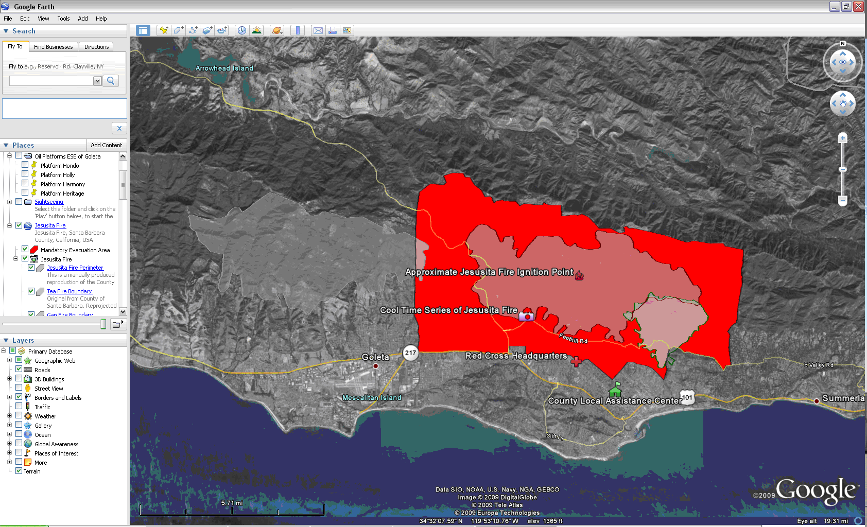
For those of you out of town or who’ve been unable to climb out of your cubes and take a look outside, Santa Barbara recently dealt with a major fire which was named the Jesusita Fire after the area in which it started. The fire began late Tuesday afternoon, May 5, and was cause for concern for most faculty and students as information began to spread. One faculty member, Dr. Rick Church, only became aware of the fire when an undergraduate who had an appointment with him observed it and asked Dr. Church if he lived close to it. Dr. Church promptly left, after seeing the cloud of billowing smoke in the direction of his home.
But, also left behind at UCSB, were some graduate and undergraduate students who, as geographers, were thinking about how best to disseminate information about the fire as accurately and in as timely a manner as possible. The resulting “map” started off as a collaboration between “Ethan,” also known as Mark Grosch (ex-Geography Research Assistant), and current UCSB Geography graduate student Alan Glennon. After the initial map was created, other UCSB Geographers joined the team, including graduate students Tim Niblett, Matt Niblett, and Indy Hurt; undergraduates Carlos Baez and Jake Sopher; as well as many other people from the community.
The map was created using Google Maps’ “My Maps” feature and displayed the burn locations of the Gap Fire and Tea Fire, as well as the mandatory and advisory evacuation warning areas. Initially, the map was open to any user willing to contribute information obtained from either first-hand or verifiable sources, such as Santa Barbara County, KTYD (radio), The Independent (newspaper), shortwave radio, etc. Eventually, locations for the Red-Cross Shelters, burn area, animal shelters, roadblocks/closures, power lines, and other resource information were added. Much of the map editing was done using polygon manipulation on the map and, in many cases, was more exact than the County of Santa Barbara’s map, since the pool of collaborators could meticulously edit various portions. In the case of the Jesusita Fire burn perimeter, MODIS data and information from the GeoMAC (Geospatial Multi-Agency Coordination) website was incorporated into the map long before government mapping agencies recorded it. In fact, one worker for the county posted, “Much thanks for this map and its accurate updates. I know this map has been the primary source map info for many of the Departmental Operations Centers. Strong work.” Another woman in the community wrote, “This site has been an absolute Godsend for a LOT of people. Having been an evacuee of the Gap fire for 9 days and now hosting evacuees, I was particularly glad for the historical comparisons of the Gap and Tea fire footprints! Thanks for a great job!”
The burn extent was the feature most people were interested in, along with the evacuation zones and the location of red-cross shelters. Some people posted comments to this effect saying, “Thank you all for the great work on this map!!! It’s great to have this information. Especially mapping the fire perimeter!” Another commented “Hey Glennon; I have spent approximately 8 hours combing the net, TV, and Radio to find decent information and inevitably I return to this map. Your map is the best “one stop shot” for the most up to date and valuable information out there. You have done a fabulous job integrating the MODIS imagery from the USFS here.” Another woman said, “Thank you so much to all the contributors for this map! It’s the best way to track the fire all in one place. I no longer live in SB, but I still have family there, so this is extremely useful.” Almost all comments reflected appreciation for the map and the accompanying data.
The map underwent several changes throughout its lifecycle. It was critically impacted on Thursday evening, May 7, at a time when the fire was rapidly expanding toward highway 154, when public contributors loaded MODIS fire detection data for all of North America. That effectively created a “denial of service” attack on the map, such that no one could display volunteered data. However, thanks to many volunteers and collaborators, about 5,000 data points and polygons were removed in about 4 hours. Due to the repeated uploading of the MODIS data, the map was closed to the public and limited to collaborators only. Most of those involved feel it was more than likely that someone with good intentions accidentally posted the entire MODIS dataset as well as personal addresses to the map. Other changes included the forced consolidation of data in order to best show the map, since Google limited the amount of visible layers to 30. In any case the map proved its usefulness, as more than 550,000 views were logged, and the map was featured on several websites, including the Independent and KTYD. The map can be accessed at http://maps.google.com/maps/ms?ie=UTF&msa=0&msid=113350399174193214844.00046932e9dd96f2e87cd.


.jpg)