To help combat the spread of the Ebola virus disease, the National Geospatial-Intelligence Agency is providing unprecedented online access to its unclassified geospatial intelligence products to lead federal agencies and their partners through a public-facing website dedicated to the crisis. The dynamic site, which uses Esri’s ArcGIS Platform hosted in the cloud by Amazon Web Services – both publically available services – features various base maps that provide foundational context for users, who will then have the ability to visually overlay public NGA data, as well as ingest open-source data. NGA’s first exposure of data includes geospatial layers relevant to the Ebola outbreak in Guinea, including cultural places and structures, and communication, electric power, and ground transportation infrastructure. The team will continue to update the site and will provide layers for the other affected countries soon.
Please visit on the NGA home page to view the data. Step 1: Click on Ebola Support; Step 2: Click on Advanced View and Quick View Applications for NGA provided unclassified data. We thank you for your continued interest and support of the WWHGD Working Group. We are excited at the opportunity to share unprecedented NGA data access to the unclassified community providing critical support during this time of crisis (source: email forwarded from Professor Keith Clarke, who received it from the World Wide Human Geography Data Working Group).
Paul Frommelt, writing for the NGA Office of Corporate Communications, goes on to report: “
This has the potential of being a global incident,” said Tim Peplaw, GEOINT mission manager for NGA’s Integrated Working Group – Readiness, Response and Recovery, or IWG-R3, which provides GEOINT support to humanitarian assistance and disaster relief activities. NGA’s role in the Ebola crisis has been in step with many other global events that have required the agency’s disaster support, including Hurricane Katrina in 2005, the Haiti earthquake in 2010, Hurricane Sandy in 2012 and Typhoon Haiyan in 2013, said Peplaw. The difference this time is the size of the affected area. “We are looking at multiple locations and we are trying to provide support,” said Peplaw. “It’s not single-threaded. It’s not just one event taking place, it’s happening on the entire western part of the continent.”
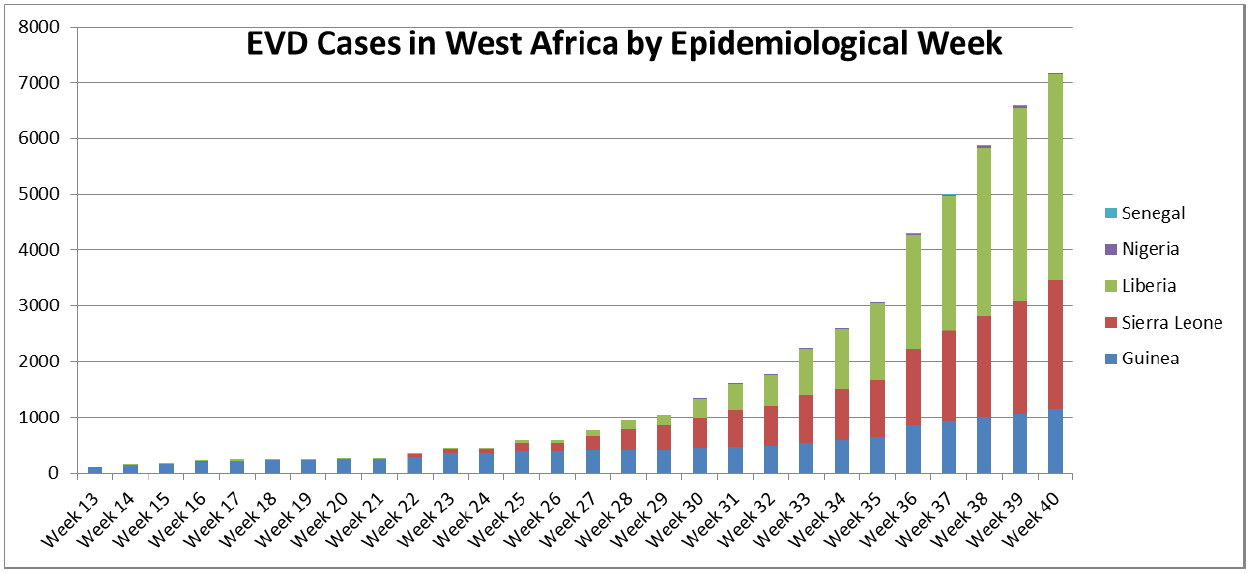
The combined size of Guinea, Liberia and Sierra Leone is 165,625 square miles, or roughly three times the size of Louisiana and 15 times the size of Haiti. Other countries like Nigeria, which has been minimally affected, or other neighboring countries, may be at risk in the future, adding to the scope of the problem. A crisis this large requires an international response of a similar size, said Martin Cox, national geospatial-intelligence officer for Africa and NGA issues manager for the Ebola crisis. So NGA is focused on unclassified support – making its products available through a public-facing portal no caveats or limits in distribution. “If we don’t keep it unclassified, the majority of the people who are working in the field will not be able to access the information that they may need to help bring this epidemic to a close,” said Cox, who added that infection rates in West Africa are predicted to grow at an exponential rate.
The large number of non-governmental organizations, or NGOs, involved in the relief effort requires NGA take a different approach to disseminating information, said Peplaw. “We want to get this stuff into the hands of NGOs as quickly as possible.” To accomplish this, NGA’s created an unclassified public-facing website to support relief efforts. The dynamic site, which uses Esri’s ArcGIS Platform hosted in the cloud by Amazon Web Services – both publically available services – features various base maps that provide foundational context for users, who will then have the ability to visually overlay public NGA data, as well as ingest open-source data. NGA’s data will provide logistical information relevant to the situation on the ground, said Steven Alness, deputy director of the Office of Future Xperience for NGA’s Xperience Directorate. “As we expose the data, we want it to be used, useful and usable,” said Alness.
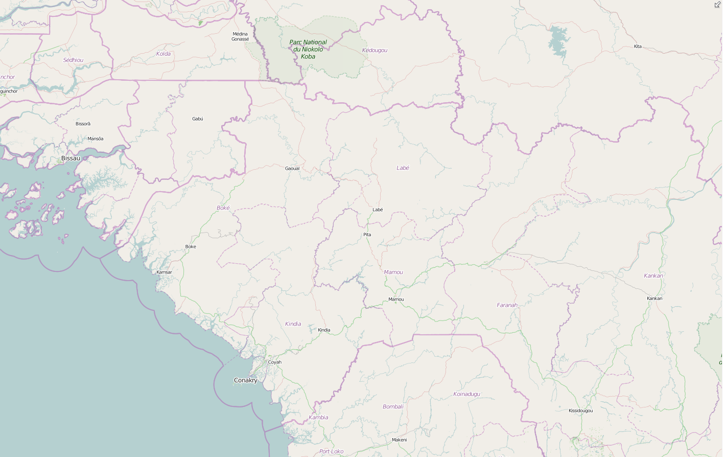
NGA’s first exposure of data includes geospatial layers relevant to the Ebola outbreak in Guinea, including cultural places and structures, and communication, electric power and ground transportation infrastructure. “For example, you will be able to see Ebola cases by province and locations of emergency treatment units,” said an IWG-R3 analyst. “Users will be able to ascertain the distance from a certain airfield to the closest emergency treatment unit.”
Traditionally, NGA provided relief workers with static products, or “snapshots in time,” said the analyst. “Those are disposable bits of information,” the analyst said. “We are providing information in a dynamic manner which is continually updated as new information comes in.” This mindset is in line with NGA’s focus on putting its knowledge directly into the hands of the user, said Cox. Doing it at a completely unclassified level, however, is uncharted territory. “The level at which we are trying to expose our data and commercial imagery products is unprecedented,” said Cox. “If they are trying to do good, why would we not want to help?”