Everything has a backstory, a forgotten history from back in the day that few remember and even fewer appreciate. But, like a war veteran’s memories, the days of infamy remain as fresh today as they were in that forgotten time. If you are new to the Geography Department or perhaps a long timer with a nostalgic bent, perhaps this story might be of interest to you.
I arrived at the “Campus by the Sea” as a wide eyed freshman in the fall of 1968. The sounds of Led Zeppelin, Janis Joplin, and Jimi Hendrix rocked the halls and walls of Anacapa dorm, Ronald Reagan was governor of California, a computer in the computer lab took up a complete wall of the room, and the Geography Department was no more than a “program” – a sort of passed over, scruffy little brother in the Social Science Department housed in a trailer. However, like society in general and the campus in particular, changes were about to occur that would chart the course of the Department for the next several years. The story of how it grew from humble beginnings into a widely respected and highly influential department is also the story of the talented and dedicated individuals who laid its foundation. The names of Golumb, Simonnet, Dozier, and others come quickly to mind, but in 1969 two individuals arrived who were to be seminal figures in the future of the Department. Two more different educators (or men for that matter) in terms of personality, outlook on life, and approach to teaching you could not find, but it was just this type of diversity that enabled the program to branch out in such diverse directions. I speak of Professors Norman Sanders and Jack Estes, the first a flamboyant Don Quixote who never met an underdog cause he didn’t like and who would lead the charge to environmental awareness in the Department, and the latter a straight shooting, analytical methodologist who would establish the Remote Sensing program, oversee its rise to national prominence, and, in the process, save the program.
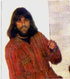
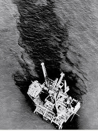
Stormin’ Norman, as he was called, was a singularly unique individual. As an avid sailor, Norm would begin class with the LA Times weather map projected on the overhead (remember, there was no internet and weather.com), and he would point out the wind and wave patterns, the tides and moon phases, storms coming down the coast, and how the weather affected our daily lives. He taught classes in celestial navigation and environmental activism and sought to put his students in tune with the environment as a living, breathing entity and with the necessity of protecting it and, hence, themselves. To the developing surf, ocean, and outdoor culture of the time, it was akin to worshiping at the feet of a prophet, and we sat in rapt attention. After the disastrous and culture shocking blowout of platform Holly and the subsequent massive oil spill along our coast (an event credited with sowing the seeds of the environmental movement), it was Professor Sanders who was at the forefront of mobilizing media attention to the situation. Soon after, he would become one of the founders of Get Oil Out! (GOO), as well as Citizens for Environmental Defense. Norm had an innate ability to make people want to get involved and the ability to teach them how to do so. He made you believe that one person can accomplish great things on their own, and that, by working together, the course of history can be altered at both a local and global scale. An illustration of this is the Great Rowboat Trek across the Goleta Slough.
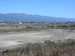
Imagine if you will coming up highway 217 and heading for the present day entrance to campus, but, instead of entering, you veer to the right and keep going along an extension of 217 that runs across the Goleta Slough along the foot of the bluffs and brings you out to Storke Road. Far fetched as it may seem, this was the University’s vision and well underway to becoming reality when Stormin’ Norman stepped in. Studying the situation and determined to come up with a legal means of putting the kibosh on a project that was backed by very powerful and well connected interests, he convinced a secretary and a grad student from the Geography office to get in a rowboat with him and at high tide rowed from Goleta Beach to Shakey’s Pizza (by the present day K-Mart) on Storke road. He therefore established the slough as a navigable waterway, and, thus, under the jurisdiction of the Army Corps of Engineers rather than the State of California for development approval. Once this became the case, enough environmental issues would be raised to effectively kill the proposal. Then Chancellor Vernon Cheadle was none too thrilled at the outcome (not to mention some local construction firms), but Norm accomplished his mission and demonstrated to his students how to fight for a cause from within the system (and nobody had to lie down in front of a bulldozer – though this was probably his next step).
An interesting side story to all this begs this question: If the project was poised to begin, where was the necessary material needed to fill in the Slough to come from? Most of Mescalitan Island (a former well-populated Chumash Village at the slough’s entrance) had been demolished as fill for the construction of SB Airport during WWII, so that was not an option. And if the fill had already been procured, what became of it when the project went south? Another story for another day.
Norman Sanders later moved (sailed I think) to Tasmania where he had a successful career as a Senator and continued(s) to fight for environmental causes. Though there are some who contend that by incurring the displeasure of the administration he hindered the growth of the Department itself, his activism was a contributing factor in the establishment of the present day UCSB Environmental Studies Department and Santa Barbara’s own environmental legacy.
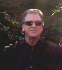
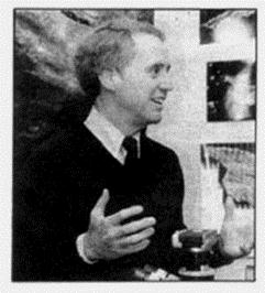
John “Jack” Estes was a horse of a different breed, not to mention temperament, and it was his work in remote sensing of the environment that would move the Department from a social science perspective to one of practical science that would see it through one of its darkest periods and helped form the nucleus of what it later became. Mr. Estes arrived on campus amid an atmosphere of growing opposition to and mistrust of the military-industrial complex, due in part to the Vietnam War. He had worked with the Defense Department in satellite imagery interpretation (if you remember something called the Cuban Missile Crisis), and, with his military background and CIA affiliations, he was at once both intriguing and suspect. Satellite imagery had long been used by the military for strategic planning, monitoring troop buildup, and other forms of covert surveillance but was just in the early stages of practical applications for other government agencies and private sector business. In contrast to Norm Sander’s reaction to the 1969 oil spill, Jack Estes rolled up his sleeves and went to work adapting the technology for the detection of marine oil pollution via satellite imagery, and, starting in the early 1970s, he conducted studies for NASA on land-use change, crop identification, water-demand modeling, and soil moisture conditions. Jack Estes simply saw the world in a more complete way than the average person and had a passion to convey that to his students. He taught aerial photography interpretation as his first class, and it was, to say the least, an eye opening experience for his textbook and classroom oriented students. Suddenly, terms such as basin and ranges, the Central Valley, watercourses, and snow pack took on new and real world meaning. Santa Barbara’s unique Mediterranean climate due to its east-west coastline and the Transverse Ranges (“Sideways” to the wine savvy) was clearly evident, and the geography of faraway places was rendered in intimate detail through the satellite’s eye-in-the-sky view. We take much of this for granted today, of course, as Google Earth shrinks our world even more, but at the time such technology was as mind expanding as any esoteric meditation technique or hallucinogenic drug. Just as Norm Sanders launched a cadre of environmental activists/disciples into society at large, Jack Estes’ students and protégés disseminated into academia, business, and government and brought their unique “world view” with them, and, by the time he died in 2001, his well-established legacy was safe with them.
Two men, different in so many ways, passionate in their own beliefs, yet illustrative of the Yin/Yang principle that made UCSB in the early 70’s such a fertile ground for innovative thinking. A good thing to remember in these “if I’m right you must be wrong” times.