The word tephrochronology comes from the Greek téphra (ash) and kronologi (chronology), and it is applied to a geochronologic technique of dating layers of volcanic ash. Tephra is the word used to describe the solid material ejected into the atmosphere during a volcanic eruption, and, during major eruptions, such material travels great distances and settles to earth in distinct, volcanic ash layers which can be distinguished using geochemical fingerprinting techniques.
According to tephrabase.org, “tephra from the 1259 AD eruption of El Chichon, Mexico…has been found in both the Greenland and Antarctic ice caps (Palais et al., 1992). Small tephra shards (2-3 µm) from the eruption of Pinatubo circled the globe several times after the 1991 eruption. The interest in the study of tephra layers has proceeded on two fronts: firstly, there is interest of volcanic impact on climate and the environment and secondly, as a chronological tool. Climatological and palaeoenvironmental research has involved studies on the possible major impact of volcanic eruptions on climate, from the possible intensification of ice ages (Ramaswamy, 1992) to localised or short-term climatic change (Baillie and Munro, 1988). The large 1991 eruption of Pinatubo, for example, produced a large eruption column that had a small, but noticeable effect on the Earth’s climate (Koyaguchi and Tokuno, 1993). The use of tephra layers as a chronological tool (tephrochronology) was originally developed in Iceland (Thorainsson, 1944) and has since been applied to other volcanically active areas such as Alaska, New Zealand and Mexico. This technique allows isochronous marker horizons, formed by tephra layers, to be mapped across inter-continental scale distances. These can form a dating framework against which other dating techniques can be checked and validated.”
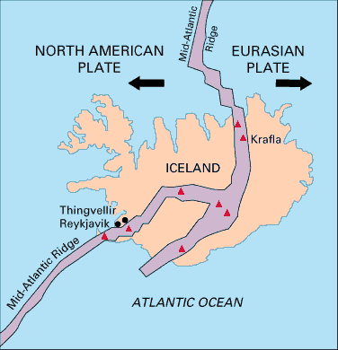
The large amounts of tephra being produced by Eyjafjallajökull’s eruption “are a result of the interaction between the lava and the glacier which overlies the volcano. The erupting lava melts the overlying ice, creating steam, and it is the rapid explosive expansion of the ice to steam which literally blows the molten lava into fine ash fragments (very similar to what happens if you pour water onto an oil fire). This type of activity is typical of Iceland’s subglcial volcanoes and is responsible for Iceland having a fantastic record of past eruptions in its soils. This is why Iceland is probably the best place in the world to use tephrochronology” (Ibid.).
Eyjafjallajökull is still erupting, although, on April 21, the Icelandic Civil Defense Agency reported that its activity had lost 80% of its intensity since it peaked. According to the Institute of Earth Sciences/Nordic Volcanological Institute, 100 million m3 of tephra has been discharged into the atmosphere by Iceland’s recent volcanic eruption. While this is a significant quantity of ash and has had a major impact on air travel over the past few days, the eruption itself is considered to be modest in geological terms. Modest or not, it will leave its mark in the geological record, and it serves as a reminder that such events will continue to occur. Following the 2010 eruptions, on 20 April 2010, Icelandic President Olafur Grimsson said “the time for [nearby and much larger] Katla to erupt is coming close … we [Iceland] have prepared … it is high time for European governments and airline authorities all over the world to start planning for the eventual Katla eruption” (Wikipedia).