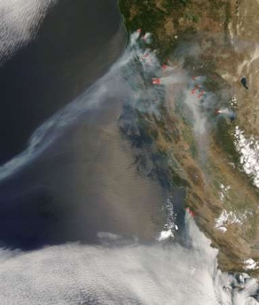
What a difference a month makes. It’s been just over a month since dry lightning storms set fire to vast areas of Northern California on June 21. That conflagration was soon followed by two major fires in Central California: the Basin Complex Fire in Big Sur and the Gap Fire in Santa Barbara County. At one point, over 2000 fires were burning in California; as of July 21, there were only 33. A total of 1480 square miles (978,180 acres) were scorched in what is considered the largest fire event in California history. Thanks to the efforts of over 20,000 firefighters, there were “only” two fatalities and about 125 homes destroyed throughout the state.
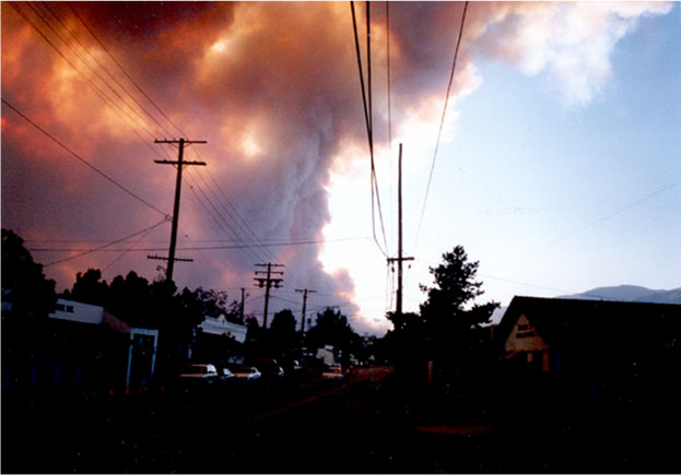
The misnamed “Gap Fire” began on July 1, around 5 pm, and quickly grew from 300 acres to 3000 acres in the next 36 hours. The flames were visible from Ellison Hall on July 2. The perimeter of the fire got within 4 miles of the northernmost point of the UCSB campus, and it forced the evacuation of thousands of people in the Goleta and foothill areas adjacent to the inferno. Old chaparral which hadn’t burned in over 55 years fueled flames as high as 100 feet, and evening “sundowner” winds threatened to create a fire storm that could move at 60 mph or more and devastate a major urban community within minutes (as was the case in the 1990 Painted Cave Fire). The Gap Fire quickly became the number one priority fire in California. Thick smoke and ash played havoc with Edison’s main transmission lines and resulted in near-daily power outages for a week, as well as serious air pollution. In all, over 10,000 acres burned, and it will have cost over $20 million to contain the conflagration—but no lives or homes were lost.
The Gap Fire is now 97% contained and full containment is expected by July 28, 2008. “There is still a small section of the fire on the northwest side that is not contained. This is in a very steep and inaccessible area where it is unsafe to put firefighters. The area will be watched closely. Meanwhile, firefighters are repairing damage caused by the act of suppressing the fire. For example they are repairing dozer lines and roads used by heavy equipment” ).
Hazards and Risks is a major focus in Geography, and the UCSB Department of Geography is well equipped and, ironically, well situated to study one of the main ones – fire. Professor Dar Roberts maintains a lab that is devoted to such things—his Visualization and Image Processing for Environmental Research Lab, better known as the VIPER Lab, specializes in research on the remote sensing of vegetation, land-use/land-cover change, plant physiology, spectroscopy, and wildfire and fire ecology. Firefighters and ancillary personnel (and pure luck regarding the weather) saved us at the end of the day, but the geographic information they used to such good effect was provided by experts in GIS, remote sensing, and environmental research.
A note on “sundowners” in relation to Goleta: “The city’s geography at the feet of the Santa Ynez Mountains has made it subject to sudden, extremely hot winds locally called “sundowners,” similar to the more famous Santa Ana winds in the Los Angeles and San Diego regions. They are caused by high pressure drawing dry air from the inland side of the mountains, whereupon they can become superheated as they rush down the city’s side. On June 17, 1859, a sundowner wind rushed through Goleta and rapidly raised the temperature to 133 degrees Fahrenheit (approximately 56 degrees Celsius) in a matter of minutes. People were forced to take shelter immediately; when they emerged they saw that most animals and plants had been killed. It was the highest temperature recorded in the United States until 1913” (From the Wikipedia article on the City of Goleta).
Editor’s note: the title of this article is a reference to the poem “Fire and Ice” by Robert Frost (1874-1963): “Some say the world will end in fire,/ Some say in ice./ From what I’ve tasted of desire/ I hold with those who favor fire./ But if it had to perish twice,/ I think I know enough of hate/ To say that for destruction ice/ Is also great/ And would suffice.” Article by Bill Norrington