The new Guinness World’s Record title for “longest-operating Earth observation satellite” has been set by NASA’s Landsat 5, according to an email from Guinness World Records to NASA Goddard Space Flight Center. Landsat 5 has delivered high quality, global data of Earth’s land surface for 28 years and 10 months, outliving its three-year design life. The satellite was launched from Vandenberg Air Force base in Lompoc, California on March 1, 1984. Landsat 4 and Landsat 5 were built at the same time, with identical instrument payloads: the Multispectral Scanner System and the Thematic Mapper (source).
“This is the end of an era for a remarkable satellite, and the fact that it flew for almost three decades is a testament to the NASA engineers who launched it and the USGS team who kept it flying well beyond its expected lifetime,” said Anne Castle, Department of the Interior Assistant Secretary for Water and Science. Landsat 5 was originally designed to be retrievable by the space shuttle, and so was equipped with extra fuel, which kept the satellite operating for much longer than anticipated after the space shuttle retrieval plan was scuttled. “The efforts of the Landsat team were heroic. Landsat 5 could not have lasted so long without the dedication and devotion of the USGS flight operations team that overcame a number of difficult technical challenges over the last 12 years,” said Jim Irons, LDCM project scientist. Not only did they keep the satellite going, said Irons, but in doing so, “Landsat 5 saved the Landsat program. This satellite’s longevity preserved the Landsat program through the loss of Landsat 6 in 1993, preventing the specter of a data gap before the launch of Landsat 7 in 1999” (source).
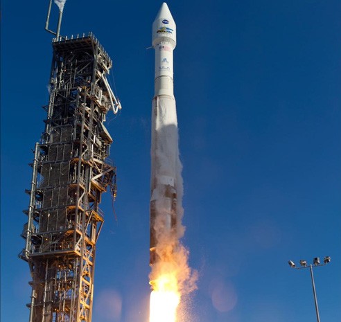
NASA’s latest Earth-observation satellite blasted off on February 11, continuing a storied four-decade effort to track environmental change and resource use across the planet. The Landsat Data Continuity Mission launched at 1:02 p.m. EST (1802 GMT/10:02 a.m. PST) from Vandenberg Air Force Base in California, riding a United Launch Alliance Atlas 5 rocket into space without any apparent hitches.
The $855 million LDCM spacecraft is the eighth satellite in the history of the Landsat program, a joint NASA/United States Geological Survey (USGS) project that has been monitoring forest loss, glacial retreat, urban sprawl and other phenomena continuously since Landsat 1 lifted off in July 1972 (source).
The Landsat program is the longest running enterprise for acquisition of satellite imagery of Earth. On July 23, 1972 the Earth Resources Technology Satellite was launched. This was eventually renamed to Landsat. The instruments on the Landsat satellites have acquired millions of images. The images, archived in the United States and at Landsat receiving stations around the world, are a unique resource for global change research and applications in agriculture, cartography, geology, forestry, regional planning, surveillance and education. Landsat 7 data has eight spectral bands with spatial resolutions ranging from 15 to 60 meters; the temporal resolution is 16 days (Wikipedia: Landsat program).