Professor Dar Roberts is the lead author of an article about recent advances in the use of satellite and airborne data to estimate live fuel moisture in California shrublands (Roberts, D.A, Dennison, P.E., Peterson, S., Sweeney, S. and Rechel, J. 2006. Evaluation of AVIRIS and MODIS Measures of Live Fuel Moisture and Fuel Condition in a Shrubland Ecosystem in Southern California, J. Geophys. Res. Biogeosciences Vol. 111. G04S02, doi: 10.1029/2005JG000113, 16 pp.). Dar’s article and findings have just been featured on the web sites of both the BBC (“Eye in the sky for wildfire risks”) and NASA (“NASA Data Helps Pinpoint Wildfire Threats”). The following is an extract from the NASA feature, written by Mike Bettwy (Science Writer / Editorial Assistant for the NASA Earth Science News Team):NASA data from earth observation satellites is helping build the capability to determine when and where wildfires may occur by providing details on plant conditions, according to a recent study. While information from sophisticated satellites and instruments have recently allowed scientists to quickly determine the exact location of wildfires and to monitor their movement, this geoscience research offers a step toward predicting their development and could complement data from National Oceanic and Atmospheric Administration weather satellites used to help calculate fire potential across much of the United States.
By studying shrublands prone to wildfire in southern California, scientists found that NASA earth observations accurately detected and mapped two key factors: plant moisture and fuel condition – or greenness – defined as the proportion of live to dead plant material. Moisture levels and fuel condition, combined with the weather, play a major role in the ignition, rate of spread, and intensity of wildfires. “This represents an advance in our ability to predict wildfires using data from recently launched instruments,” said lead author Dar Roberts, University of California-Santa Barbara. “We have come a long way in just the past 5 to 10 years and continue to gather much better data on the variables critical in wildfire development and spread. Improving the role of satellite data in wildfire prediction and monitoring through efforts like these is critical, since traditional field sampling is limited by high costs, and the number and frequency of sites you can sample. This new data on the relative greenness of a landscape also allows us to see how conditions are changing compared to the past.”
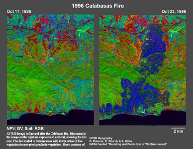
AVIRIS image before and after the Calabasas fire. Blue areas in the image on the right are exposed ash and soil, showing the fire scar. The fire tended to burn in areas with lower ratios of live vegetation to non-photosynthetic vegetation. Photo courtesy of Dar Roberts. Click Image to enlarge
Complete write-ups can be found at: http://www.nasa.gov/centers/goddard/news/topstory/2006/wildfire_threat.html and http://news.bbc.co.uk/2/hi/science/nature/6196277.stm