What do you do with a double major in Geography and Political Science (and a minor in History)? How many maps are housed in the Geography and Map Division of the Library of Congress? How and why did George Washington choose the site of what was to become the nation’s capital? Is Dar Roberts the best professor at UCSB? Why are UCSB Geography t-shirts so popular at the Library of Congress? What does a Bonne projection look like? Gina Fischer just sent the following (and fascinating) account of her UCSB – Washington D.C. Program (UCDC) internship in the Geography and Map Division of the Library of Congress. Read on!
I just graduated from UCSB where I was a Geography and Political Science double-major and a History minor. I’m really into historical geography and wanted to gain some hands-on GIS experience, so I applied for the UCDC program for winter quarter. The program director, Melody Johnson, got me in contact with Dr. Hebert who is the chief of the Geography and Map Division at the Library of Congress. While I interned there, they taught me a plethora a new things.
First, I learned how the maps are cataloged, which is complicated because the division is in the basement of the Madison building, is the size of two football fields, is full of six-foot tall map drawers, and houses over 5 million maps; it also has globes and atlases – in total, the world’s largest collection. Then they taught me how to answer “Ask-A-Librarian” questions submitted by the public. Many researchers and genealogists submit questions. For instance, one person asked for a map from the 1850s of the township of Lisnahilt in Ireland because that is where he thinks his ancestors are from. Another person needed information about the south during the Civil War, so I got to pull out and analyze original civil war maps and then type a response to the person.
I also worked with the scanning and digitizing team and scanned maps so the public can access them on the internet. The first set I worked on was an 1885 set of maps of Mexico’s states, given to the US government just after they were made. These maps were made on a type of wood paper, so they are particularly fragile and were literally crumbling. With the specialized scanners, they are now scanned and edited and should be on-line by now. Scanning and digitizing is very tedious, but it helps preserve the maps in the long run.
After a few weeks, I was able to work with Ginny Mason, who is the head cartographer for the Congressional Cartography Program at the division. Any member of congress can request a GIS map of anything, and Ginny prepares it. While I was there, she was finishing one map that compared school locations to registered sex offender data that a House Member from NY used as a visual aid for legislation he was pushing. Another map she made was a detailed GIS map of Iraq that analyzed data of oil fields; Shiite, Sunni, and Kurdish locations; and other information. I got to use GIS to database a key of an old set of Atlantic-Neptune maps. It is difficult to explain, but I basically had a paper map to follow and drew that information in GIS by creating polygons from the paper original.
Finally, the UCDC program stipulates that you have to work on one research paper while you are in DC. I chose to research the geographic perspectives in choosing Washington, D.C. as the nation’s capital. In the rare collections, the division has original maps that President George Washington drew when he was 15 years old. He was a land-surveyor for his first job, which is really neat to know. Anyways, I researched and argued that historians do not always paint a full picture of how historical things happened and why (Dar Roberts’ Historical Geography class taught me to understand the world from a historical-geographic standpoint, which paints a much fuller picture of the world). Anyways, I argued that Washington’s role as a cartographer and the connections he made at 15 led to years of interest in developing the Potomac River and making some place near Georgetown a major place of commerce in the US. In fact, I used original maps from the division and many letters of correspondence and other primary sources to prove that many wealthy men, friends of Washington, wanted this area developed for 40 years before it became the capital. Basically, when the north and south needed to make a compromise, they just didn’t happen to pick what became D.C. randomly, which is what historians preach. Instead, geographic factors, motivated by economic interest, made D.C. a place of great importance long before we were even an independent country. I presented my paper to the Chief and others at the library and they all really enjoyed it. My professor through the program gave me an A+ and an “Excellence in Research Award” for it.
So, my experience in D.C. and interning at the Geography and Map Division was really a great opportunity. I know that is a lot of information, but so much goes on there. And, I know the Division is always looking for interns, and unlike most internships in D.C., they do not save a bunch of grunt work for interns to do, but instead everything I learned was because they took the time to teach me for my own benefit.
Oh and P.S. I wore my “I heart Geography” t-shirt my last day there and everyone loved it, so I told them I’d arrange to get them some. And I love the Geography Dept. at UCSB. Geography is a really useful major—it really challenged me to tackle tough concepts, and I feel like I have a much deeper understanding and appreciation about the world and how it works because of it. And I must say, Dar Roberts is probably the best professor I had at UCSB, and I took a lot of classes. He challenged me to understand the world from a totally different lens, and I appreciate that very much.
Editor’s notes:
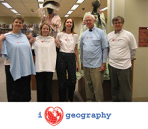
T-shirt toting staff of the Geography and Map Division at the Library of Congress pictured left to right are Diane Schug O’Neill, Ginny Mason, Sammie McCarthy, John Hebert (Chief of the division), and Jim Flatness.Dylan Parenti, the Computer Network Technologist for Dar Roberts’ Advanced Remote Sensing Group, gets the credit for the design of our new t-shirts. The “heart” on the front is a Bonne Projection (yes, it really looks like a heart), and the back graphic is based on an Adams Hexagonal Rhombic Projection. The t-shirts were sold in support of the UCSB chapter of Gamma Theta Upsilon (GTU), the International Geographical Honors Society.
The UCDC program is a residential program that combines research, internship, and optional elective coursework for undergraduates with any major in their junior or senior year at UCSB. For more information, see .