An Emergency Operations Center, or EOC, is a central command and control facility responsible for carrying out emergency management, and ensuring the continuity of operation. The UCSB campus EOC is responsible for the strategic overview and coordination in the event of a disaster (see . Tylor Headrick (B.A. in Geography with a GIS emphasis, 2012) used his training in Geography to work as an intern at the UCSB EOC and went on to work as an administrator on the County level after graduating:
“I started working as an intern at the UCSB EOC through the Geography Department and then the county EOC where I became familiar with the webEOC program. I then approached them for a summer internship, and they decided to hire me for the year to work on webEOC and to provide training for other jurisdictions. I now work at the Santa Barbara County office of Emergency Management as the webEOC Administrator.
webEOC is a dynamic web-based program that helps facilitate and document communication during an emergency incident. Real time communication and documentation are essential to the coordination of the many parties involved during an incident. I have been working on editing the webEOC program for Santa Barbara County and its jurisdictional partners so that it will be easier for those in the incident to communicate and send resource requests. I have also been going throughout the county to the various cities to give training to the staff of other EOCs.
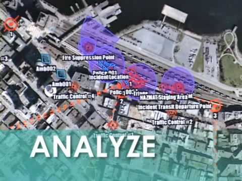
I’m also working on mapping alternatives for the county EOC and getting together a GIS database that can be easily accessed during an emergency. Geography and GIS skills can be especially important in an emergency situation where maps and visual representations of the incident are essential to those tackling the incident, as well as to the public. Pulling up the right data layers is essential in an emergency as various agencies are all concerned with different sets of data such as parcels, ‘vulnerable population’ locations, utilities, and other unique datasets.” Kudos to Tylor!