Professor Ed Keller has just had a major article published in Geomorphology (Melosh, B. and Keller, E. (2013). Effects of active folding and reverse faulting on stream channel evolution, Santa Barbara Fold Belt, California. Geomorphology 186: 119-135). Coauthored with Benjamin Melosh, one of Ed’s former grad students at UCSB and now a PhD candidate at McGill University, the article is a stark reminder that the occurrence of a major earthquake in Santa Barbara is not a matter of “if” but of “when.” The following is a simplified version of the article, which Ed was kind enough to provide at the editor’s request:
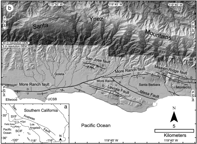
The Santa Barbara Fold Belt (SBFB) from Carpinteria to Ellwood and into the Channel is an area of active crustal shortening (the rate of shortening is about one fourth of an inch per year). Anticline folds such as La Mesa, Riviera, Hope Ranch, More Mesa, and Ellwood Mesa are generally east to west linear hills. Eventually, the Santa Barbara Channel will close due to the shortening, and the Channel Islands will collide with the mainland.
Changes in channel position and erosion of stream channels into the landscape are the result of lateral fault and fold growth with tectonic uplift. Rates of uplift are impressive at 3 to 6 ft. per thousand years. This would produce up to about 1 mile of vertical relief in one million years. Of course, erosion along with uplift would greatly reduce the relief. Highest peaks in the range are above 4,500 feet and the range is probably only a million years or so old. Rates of incision range (down cutting of streams) are from 1.25 feet per thousand years to 4 feet per thousand years. Lateral stream diversion (where streams are forced to flow east to west along folds) varies from about 0.2 miles to 4.2 miles. Minimum uplift of western Mission Ridge anticline is 2.6 ft. per thousand years, and minimum uplift on the Mesa fault is 1.1 ft. per thousand years.
A good place to observe stream diversion near UCSB is along the bike path heading east toward More Mesa from UCSB and Goleta Beach. Atascadero Creek is diverted over 4 miles west into Goleta Slough .The high ground to the south is the fold scarp of the More Ranch anticline. The anticline is over the buried Mission Ridge Fault System that extends from near the Ventura River to the east west to Ellwood Mesa and then offshore.
If the entire fault were to rupture, a magnitude 7.5 earthquake might occur. More likely, a shorter segment or two would rupture, and we could experience a Northridge (LA) type of event (Magnitude 6.7). In 1925, a magnitude 6.8 earthquake heavily damaged Santa Barbara. Similar events are certain to occur in the future.
.jpg)