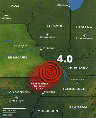
“A sharp jolt originating in the Mississippi Valley’s New Madrid Seismic Zone shattered windows and cracked walls early Tuesday as it shook the ground in 13 states. The magnitude 4.0 [3.9, according to the USGS] quake struck well before dawn at 3:58 a.m. local time in southeastern Missouri, near the convergence of the Ohio and Mississippi rivers. Local residents said the shaking lasted about seven seconds, causing minor household damage that included cracked sidewalks and items falling off shelves. A few residents as far away as North Carolina and Georgia also reported that they felt the ground move.
The New Madrid Seismic Zone was responsible for the most powerful earthquakes to strike the eastern United States in recorded history. Four intense quakes centered there in 1811 and 1812 caused damage as far away as Boston and Washington, D.C. A seismic thrust on December 16, 1811, caused the flow of the Mississippi River to reverse for a time in some locations, according to eyewitness accounts” (source).
“Earthquakes in the central and eastern U.S. are typically felt over a much broader region than in the western U.S. East of the Rockies, an earthquake can be felt over an area as much as ten times larger than a similar magnitude earthquake on the west coast. A magnitude 4.0 eastern U.S. earthquake typically can be felt at many places as far as 100 km (60 mi) from where it occurred, and it infrequently causes damage near its source. A magnitude 5.5 eastern U.S. earthquake usually can be felt as far as 500 km (300 mi) from where it occurred, and sometimes causes damage as far away as 40 km (25 mi)” (source).
“In a report filed in November 2008, The U.S. Federal Emergency Management Agency warned that a serious earthquake in the New Madrid Seismic Zone could result in “the highest economic losses due to a natural disaster in the United States,” further predicting “widespread and catastrophic” damage across Alabama, Arkansas, Illinois, Indiana, Kansas, Kentucky, Mississippi, Missouri, Oklahoma, Texas, and particularly Tennessee, where a 7.7 magnitude quake or greater would cause damage to tens of thousands of structures affecting water distribution, transportation systems, and other vital infrastructure. The earthquake is expected to also result in many thousands of fatalities, with more than 4,000 of the fatalities expected in Memphis alone.
The potential for the recurrence of large earthquakes and their impact today on densely populated cities in and around the seismic zone has generated much research devoted to understanding in the New Madrid Seismic Zone. By studying evidence of past quakes and closely monitoring ground motion and current earthquake activity, scientists attempt to understand their causes and recurrence intervals” (source).
Editor’s note: For more on this subject, see the April 27, 2010 article, “When the Mississippi Flowed Backwards.”