After the Roman Empire collapsed and Europe was repeatedly invaded and sacked, Irish monks were able to re-establish Christianity at numerous points on the Continent. One of them, by the name of Deodatus in Latin and Dieudonné in French and eventually simply Dié, settled on the Meurthe river on the west side of the Vosges mountains, in what later became a religious center of some significance, and a principal town in the lands of the Dukes of Lorraine. So it is perhaps not so surprising that exactly 500 years ago in 1507 two residents of St-Dié, Vautrin Lud and Martin Waldseemüller, geographers working under the patronage of the Duke, produced a book and map that together had a profound influence on learned people across Europe. They were convinced, based on books and letters lately received from
St-Dié grew with textile manufacturing, and by the early 20th Century had roughly 25,000 residents. It preserved its special relationship to the USA, which was reinforced by Jules Ferry, a native son who rose to Prime Minister of France, who led the move to secularize public education in France, and who was instrumental in the gift of the Statue of Liberty to the USA. But St-Dié is close to the border of Alsace, and was thus caught up in the rivalry between France and Germany which led to Alsace repeatedly changing hands. After the German invasion of 1940, Alsace was annexed to Germany, and the border took on crucial significance as Nazi forces later retreated. In November 1944, St-Dié was almost completely and deliberately destroyed by dynamite and fire, so that the arriving American forces found almost nothing standing on the north bank of the Meurthe, and little trace of the house and town in which Lud and Waldseemüller worked.
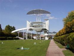
Fast forward to the late 1980s, by which time the textile industry was in decline in St-Dié as everywhere in Europe, and the town was led by a mayor, Christian Pierret, who had recently left the position of Minister of Industry in the French government. How to rejuvenate a dying town that enjoyed a spectacular location in the Vosges mountains but was poorly connected to such major centers as Strasbourg and Nancy? First change the name by adding -des-Vosges, linking the town to its attractive surroundings, just as the city fathers of Pittsburg added an h at the end of the 19th Century to give the city more class (a move that was followed incidentally by none of the other Pittsburgs in the US). Second, acquire a spectacular building originally designed for the French bicentennial in 1989 whose designers were said to have been inspired by early aircraft and the movie Jonathan Livingston Seagull (La Tour de la Liberté, right), and locate it across from the Hôtel de Ville (city hall). Third, find a topic for a festival and persuade the French government and European Union to appropriate funds. Thus was born the St-Dié Festival International de Géographie (le FIG), an October event which annually attracts more people than the population of the town, and the Prix Vautrin Lud, the Nobel Prize of Geography.
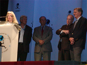
There are only five original Nobel prizes (Chemistry, Physics, Medicine, Peace, and Literature), though a sixth in Economics was later added. Many other disciplines wish they had one, and may even have obtained some kind of recognition from Stockholm, as St-Dié has for its Prix Vautrin Lud. In the 19 years since le FIG was started, the prize had gone to five American geographers – Brian Berry, Peter Gould, David Harvey, Gilbert White, and Allen Scott – and on October 4th I became the sixth. Denise Pumain, a prominent French geographer and chair of the international jury, read the citation; the Mayor provided a simultaneous translation; and I gave a prepared and very badly pronounced speech of thanks in French. The ceremony included several local politicians, and a Master of Ceremonies dressed in 17th Century costume. This year’s FIG theme was the global energy crisis, and the Mayor gave an hour-long speech on global climate change that included very specific ideas on what individuals could do, and on what politicians needed to do if they wanted to keep being elected, and made Al Gore look like, well, Al Gore. There was a Gala Dinner attended by 600, visits by senior French personalities, a market of various regional foods, talks on a vast range of topics, a book fair, a featured country (Romania), a boutique of FIG stuff, and late-night conversations in coffee bars. I can’t imagine a city of 25,000 in the US pulling off anything remotely as impressive, but then the Mayor is clearly a very unique person, and the French are clearly very serious about geography.
St-Dié itself provides a very moving setting for le FIG. The original railway station still stands on the south bank of the river, but the entire north side has been reconstructed, leaving no trace of the medieval street pattern. One very compelling piece of earlier masonry carries plaques commemorating the Nazi deportation of St-Dié’s Jewish children, and has been incorporated into the new museum. Beside it is a painstakingly reconstructed cathedral with stunning stained glass evoking images of the town in flames.
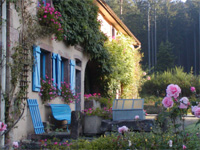
Fiona and I made a week of it. We were accommodated at La Cholotte, a farmhouse about 15km from St-Dié run by Marie-Genevieve Cholé and her partner that is apparently a favorite of François Mitterand. We rented bikes in Strasbourg and in the vineyards around Colmar in Alsace, before driving back to Frankfurt through the Black Forest. The country is not as spectacular as the Alps, but in early Fall has a beauty all of its own, and the Vosges rise to 5,000 ft. Le FIG is world class, and as much an essential destination for any serious modern geographer as the AAG or the ESRI user conference. But be warned, next year’s theme is War and Territory.


