Alumnus Kirk Goldsberry has been making headlines in geographic circles recently with his use of Geographic Information Systems to map “food deserts”—areas where consistent access to healthful food is limited or nonexistent. (The results of this work appear in multiple journals and have also appeared in American Scientist and ArcUser magazines.) Kirk describes his current research as follows:
One of my most recent research projects uses GIS to reveal key disparities in access to fresh produce in urban areas. Although countless recent studies from diverse perspectives have examined so-called “food deserts” in American cities, my colleagues (Chris Duvall of University of New Mexico, and Phil Howard of Michigan State) and I saw an opportunity to contribute to this emerging research domain by applying advanced geospatial methodologies to visualize “nutritional terrain” with newfound precision. The main idea was to collect highly precise input data and apply an ensemble of accessibility models to shed light on the complex interactions between place and nutritional opportunities in two pilot study areas: Lansing, Michigan, and Albuquerque, New Mexico.
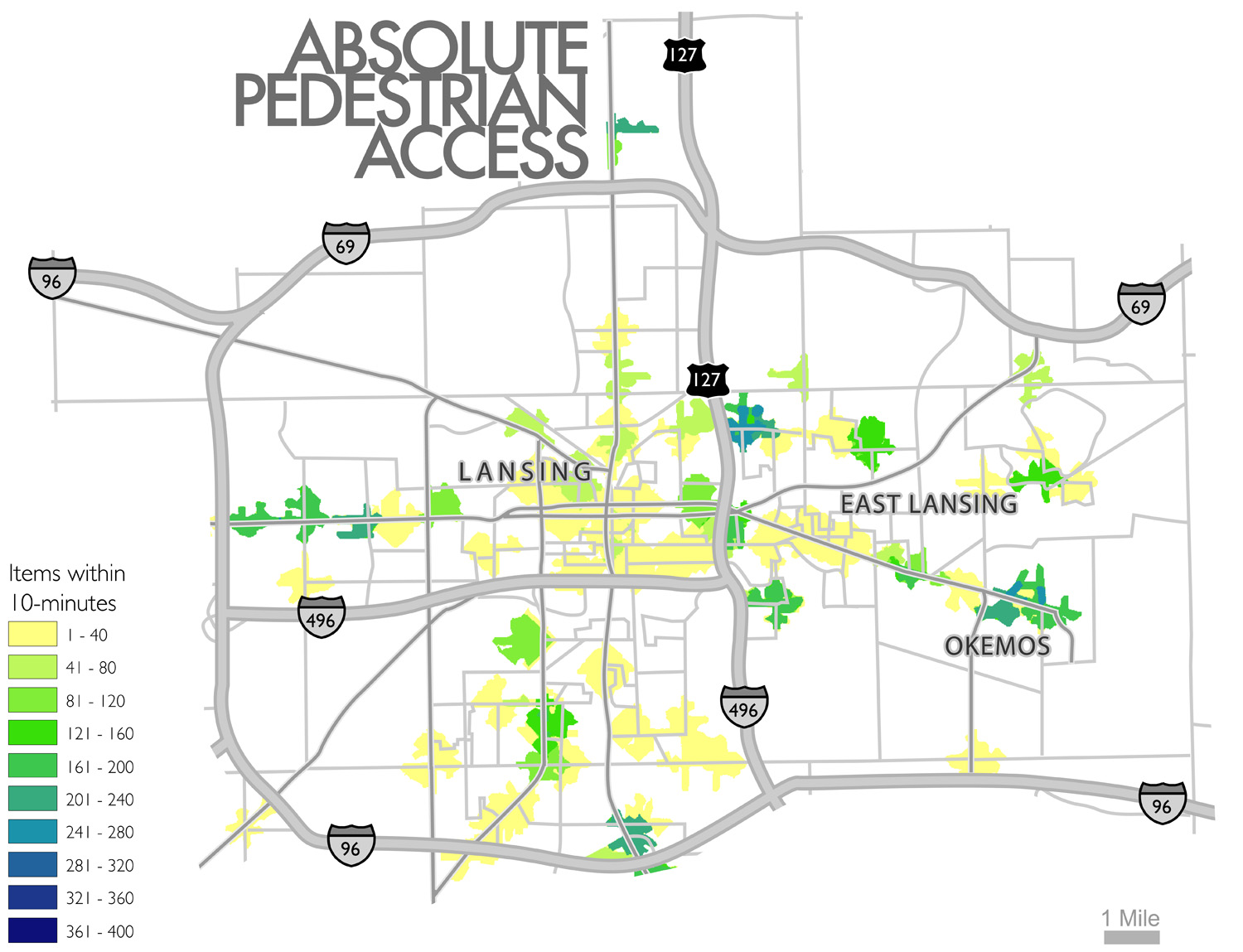
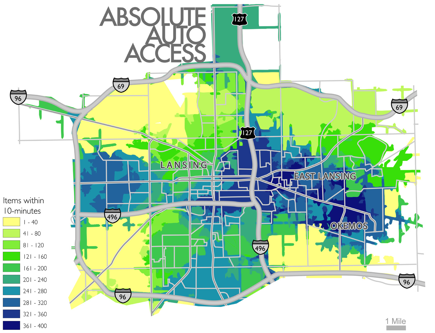
The study was unique in part because we visited every produce retailer in each city (n = a lot of freaking stores) and recorded the presence/absence of over 500 unique produce items. This “nutritional census” enabled us to model accessibility, not just to retailers, but also to individual produce items (e.g., plums, basil, bok choy). As a result, we demonstrated that virtually every fresh produce item in an urban area possesses its own unique geographic access signature (instead of watersheds, think of water-chestnut-sheds). But perhaps more importantly, we overlaid these individual item signatures to easily map out cumulative access indices that indicate how many unique items are within some cost constraint of any location in the study area. For example, we were able to visualize how many unique produce items were within a 10-minute walk or a 10-minute drive of any residence in either study area.
There are three key findings that emerged:
- Place matters: Different urban zones have different levels of access to fresh produce. In both study areas, there are areas near supermarkets that enjoy ready and convenient access to hundreds of fresh produce items; however, there are also many densely populated zones that do not enjoy this convenience. In fact, a majority of residences in both study areas are more than a 10-minute walk from any fresh produce.
- Mobility matters: Speaking of walking, mobility is a huge determiner of fresh produce access in American cities. People who rely on pedestrian travel experience a vastly inferior food environment than those who have automobiles (or access to automobiles). For example, although most people can’t walk 10-minutes to acquire any fresh produce, almost every residence in both study areas is within a 10-minute drive of hundreds of fresh produce items. Consequently, so-called food deserts disproportionately affect certain car-less populations.
- Parameters matter: Lastly, we also concluded that studies of food environments are quite sensitive. There are infinite ways to model access (go ask Rick Church if you don’t believe me) and each will produce a unique result. Therefore, as more and more health scientists attempt to link food environments and health outcomes (obesity, diabetes) it is imperative that careful consideration is given to modeling approaches; too often we see studies incorporate only one modeling approach with one set of parameters.
When it comes to studying food environments, geographers have a lot to offer. As we seek to better understand the complex interactions between space, time, and human health, GIS and Cartography are clearly vital mechanisms.