“On August 20, 1920, the United States opened its first coast-to-coast airmail delivery route, just 60 years after the Pony Express closed up shop. There were no good aviation charts in those days, so pilots had to eyeball their way across the country using landmarks. This meant that flying in bad weather was difficult, and night flying was just about impossible.
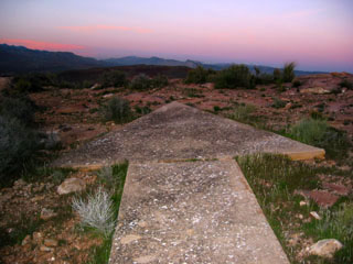
The Postal Service solved the problem with the world’s first ground-based civilian navigation system: a series of lighted beacons that would extend from New York to San Francisco. Every ten miles, pilots would pass a 70-foot concrete arrow on the ground which was painted a bright yellow. At the center of each arrow there would be a 51-foot steel tower, topped by a million-candlepower rotating beacon. Below the rotating light were two course lights pointing forward and backward along the arrow. The course lights flashed a code to identify the beacon’s number. If needed, a generator shed at the tail (or feather end) of each arrow powered the beacon and lights.
By 1924, just a year after Congress funded it, the line of giant concrete markers stretched from Rock Springs, Wyoming to Cleveland, Ohio. The next summer, it reached all the way to New York and then extended all the way to San Francisco by 1929.
Around 1926, the new Aeronautics Branch in the Department of Commerce proposed a 650-mile air mail route linking Los Angeles to Salt Lake City and passing through Washington County. It was designated as Contract Air Mail Route 4 (CAM-4). Western Air Express, Inc. was awarded a contract to lay out the route and carry the mail. Their first flight was made on April 17, 1926 in a Douglas M-2 airplane. By 1928, the route had been marked with the cement arrows and beacon towers for navigation at night and in inclement weather.
New advances in communication and navigation technology made the big arrows obsolete, and the Commerce Department decommissioned the beacons in the 1940s. The steel towers were torn down and went to the war effort. Today, only some of the weathered cement arrows (less the yellow paint) remain” (source).
Editor’s note: Many thanks to Meryl Wieder, the Emerita MSO of the UCSB Department of Geography, for bringing this material to our attention. Alumnus John Cloud (PhD 2000), NOAA Historian of the Coast and Geodetic Survey, sent the following addenda to this article: “It may be of interest that the Coast and Geodetic Survey mapped all those routes, arrows, beacons, and so on described, in their first series of aviation maps. There were many variant names for such charts – pilot maps, air maps, etc. But the Survey, which had produced nautical charts for over a century by then, called their maps aero-nautical charts, and the term became universal. The original strip maps were oriented not to north but to the line of flight of the routes, and were beautiful chromolithographs intended to show salient features of the terrain and culture to best approximate how they looked from the air. The Survey had recently acquired Harris 5 color offset lithographic presses and they cranked up their cartography accordingly.” If interested in full resolution copies of the strip maps, contact John at John.Cloud@noaa.gov.
- Alumnus John Cloud (PhD 2000), NOAA Historian of the Coast and Geodetic Survey, sent the following addenda to this article: “It may be of interest that the Coast and Geodetic Survey mapped all those routes, arrows, beacons, and so on described, in their first series of aviation maps. There were many variant names for such charts – pilot maps, air maps, etc. But the Survey, which had produced nautical charts for over a century by then, called their maps aero-nautical charts, and the term became universal. The original strip maps were oriented not to north but to the line of flight of the routes, and were beautiful chromolithographs intended to show salient features of the terrain and culture to best approximate how they looked from the air. The Survey had recently acquired Harris 5 color offset lithographic presses and they cranked up their cartography accordingly.” If interested in full resolution copies of the strip maps, contact John at John.Cloud@noaa.gov.