The following article by Staff Writer Carl Nolte was published on page C1 in the October 3, 2010 edition of the San Francisco Chronicle and is reprinted here with Carl’s permission:
‘Paradise’ found: 70-ton elephant at S.F. Port
San Francisco’s oldest and best-known white elephant – the huge three-dimensional relief map of California that once graced the Ferry Building – has turned up at an undisclosed location on the city’s waterfront. The map was one of the wonders of the West when it was unveiled in 1924.
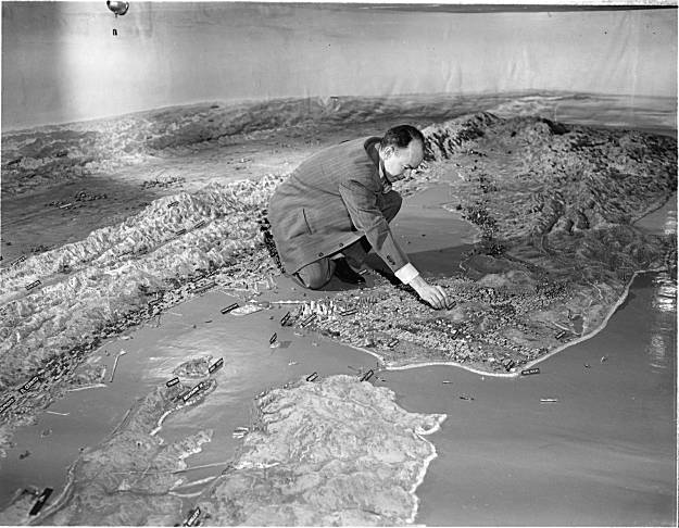
It was as long as two football fields and showed California in all its splendor, from Oregon to Mexico, with snow-capped mountains, national parks, redwood forests, a glorious coastline, orchards and miniature cities basking in the sun. It was made of plaster, wire, paint, and bits of rock and sand. In the summer of 1924, Scientific American magazine said it was the largest map in the world. It has not been seen in public for 50 years. For map fans, it is the saddest of sad stories: The map was damaged in the mid-1950s during a remodeling project at the Ferry Building and cut up into sections and put into storage in 1960. “We have no interest in it as far as I know,” Sherman Duckel, the city’s chief administrative officer, said in 1960. “We know of no place to put it or anyone who wants it.”
First the city tried to give it to the state park system, but Charles de Turk, chief of the state division of Beaches and Parks, turned it down. “I think no one else wants the map, so they are trying to give it to us,” he said. “If we owned it we would try to do the same thing.” The city offered the map for sale for a bargain price – only $1 – to anyone who would take it, restore it and display it properly. There were plans to make it a traveling exhibit, to make it the centerpiece of a tourist attraction in Redding at the head of the Sacramento Valley, to use it as a promotional gimmick. They all fell through.
The problem with the map is simple: it is huge and would cost a lot of money to move, restore and display it. The last estimate was in the range of $500,000. And that was 30 years ago. It is a classic white elephant, too valuable to scrap, but too expensive to keep. The map last surfaced in the fall of 1986, when it was stored in a warehouse at the former Hamilton Air Force Base in Novato. The California Heritage Council, which owned the map then, made a public plea for a new home for it. There were no takers. So the map is now at the Port of San Francisco, this time in 230 crates, each standing on its side in a warehouse. The map weighs about 70 tons altogether and over the years has been damaged further, though nobody at the port can say the extent of the damage.
The port says it is in talks with the California Heritage Council to take the map back. However, Heritage Council President Christopher Layton says his organization has no plans to reacquire the map. It’s too bad, in a way. The relief map – formally named “Paradise in Panorama” – was built by 25 sculptors, engineers and geographers under the supervision of J.T. Edwards in the old Mack Sennett silent movie studio near Echo Park in Los Angeles. It cost $147,000, and all 58 California counties helped pay the bill. It was installed with great fanfare on the second floor of the Ferry Building, then the busiest transit terminal in the United States. Millions of ferry commuters, travelers, and city people were said to have seen the great map, marveling at its detail and scope. It is still remembered fondly by old-timers. It was California as it was in the Roaring ’20s when it was unveiled. California had a population of fewer than four million people, no freeways, no big bridges across San Francisco Bay. The map showed San Jose as a small town and Contra Costa County covered with orchards. The famous Inland Empire of Southern California was open country.
That California vanished with time, the last old-time ferry steamer sailed away from the Ferry Building in 1958 and the building went into a long decline, and the old, and now dusty and obsolete map was relegated to the dustbin of history. And there it remains. The Port of San Francisco has no plans to be anything but stewards of its storage, and no one else has come forward in half a century to rescue the map. The situation is better for a smaller relief model of San Francisco built by the Works Progress Administration in 1940 and stored in a UC Berkeley warehouse. Gray Brechin, the UC scholar who rediscovered the WPA map last month, said he has several promising leads from organizations interested in displaying the model. But the model is a mere 41 feet by 37 feet, only a fraction of the size of the California relief map. In the world of big maps, smaller is better.
Editor’s note: Thanks to alumnus John Cloud (PhD 2000) for bringing this fascinating article to our attention.