In 1975, a major new venture was undertaken in the wholesale reconstitution of the Geography department under Professor David Simonett, a distinguished geographer from Australia. Within five years, the staff of five faculty members, all but one of them hired in 1975, had doubled to ten, extramural research funds had reached the level of $650,000 annually, and the graduate program was expanding rapidly (approval to offer the doctorate was received at the opening of 1980).
The principal impetus toward this swift development came in the vigorous activity of the Department’s Geography Remote Sensing Research Unit (RSRU), which quickly gathered an international reputation for imaginative application of recently developed remote sensing technology, using, among other sources, satellite-generated data. Aimed at earth resources management, the program developed and put to use a sophisticated data processing system. Originating in 1971, when Professor John Estes gathered a research team in remote sensing, the unit was soon working with geologists, engineers, physicists, chemists, computer scientists, and environmental scientists on remote sensing projects around the world which focused on forests, oceanography, farming, water resources, soils, and similar phenomena. (Robert Kelley, Transformations: UC Santa Barbara 1909-1979, published by the Associated Students in 1981, Page 118).
Computer processing of images was done in the RSRU of Geography before 1978, but in black and white only, mostly line printer overstrike output on 14" folded paper which was then taped together and hung on the wall due to its size. By 1978, RSRU was using the VICAR-IBIS package. The software was supported in the Engineering Department — initially on a VAX 1145, then on a VAX 1170. Both machines were huge and expensive, with only a small fraction of the processing power of today’s desktop PCs.
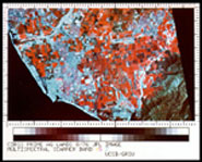
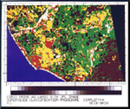
At the time, RSRU did mostly single image digital processing, but also some multidate image overlay and analysis (raster mode only). Sometime around 1979, digital/optical film scanner and film writers were added to the system to allow digital image input and output. This equipment generated the first color digital images produced in the Department
These images were generated as a part of a Geography Department remote sensing study of prime agricultural land in the State of California. To produce these images, three bands of the original MSS data were photo-optically converted to individual black and white film positives. These were then pin registered and printed using an additive color photographic process. The total time required to produce an image was approximately 60 hours.
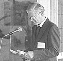
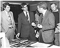
To the left is a photo of Jack Estes speaking with then Governor Jerry Brown during a tour of the Map and Image Library, circa 1979. The individuals shown in the photo, left to right, are: Rusty Schweikert (former astronaut and, at the time of the photo, Director of State of California Space Institute), Governor Brown, Jack Estes, and a GRSU researcher.
RSRU first began to use the Earth Resources Data Analysis System (ERDAS) in 1984. It ran on an IBM-PC at the blinding speed of 88 MHz. The hard drive, which cost approximately $5,000, was 20MB (that’s Megabyte, not Gigabyte). This machine allowed researchers to display and process an entire quarter of a MSS scene at one time. ERDAS was used to do remote sensing image processing and GIS. Most of the processing was in raster mode, but some was done in raster/vector mode (above information and photos courtesy of Joe Scepan, staff member of RSRU).
(Editors note: Material taken from articles about the history of the Department written by Keith Clarke and Susan Baumgart, dated October 22, 2002; see http://archive.geog.ucsb.edu/more/history_articles/computer_history.htm)