The following is a front page Daily Nexus article of Feb. 11, 2013 (Vol. 93, No. 68) titled “Geography Dept. Creates Map of Campus, Local Features” by Samhita Saquib, Staff Writer:
The map, which has been in the works since 2008, has multiple layers users can select to browse various food establishments, different levels of signal strength across campus, and metered parking spots or parking lots, in addition to other campus features. On the day of its debut, the site received 1,200 visits.
Development of the map began in February 2008 under the leadership of Dylan Parenti – the current information technology manager for the Geography Dept. – but the project has seen input and leadership from various faculty members, graduate students, and undergraduate students. According to Parenti, the team that developed the map is currently working on a feature that will allow students to type in a professor’s name or course number to display the exact location of the classroom for a particular course.
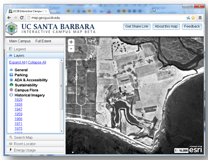
Additionally, the map has a number of eco-friendly aspects to it, including a feature that illustrates the locations of all recycling bins, techno-trash cans, and hydration station locations. The map also highlights trails for self-guided tours, such as tours of the campus flora that were constructed by using data provided by the Cheadle Center for Biological and Ecological Restoration. In addition, the map also has historical features, according to Bryan Karaffa, who is project manager for the map. “They made these tours out of it so you can go around campus and take an ethno-botanical tour. They have a little description about the plants,” Karaffa said. “There are also aerial images of Isla Vista dating back to 1925, so users can see how exactly the area has developed over the years.”
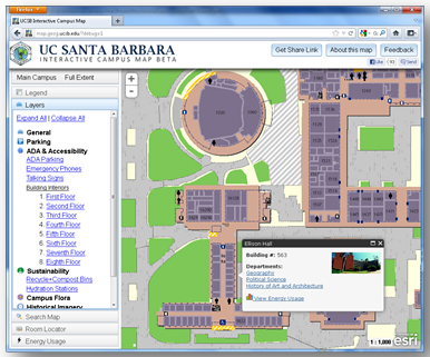
Geography Dept. Sustainability Coordinator Katie Maynard said the interactive map allows the sustainability program to help reduce the campus’s overall environmental impact. “Through the interactive campus map, we have the opportunity to highlight buildings that were designed to save energy and water, and we have an opportunity to talk about energy efficiency efforts on campus,” Maynard said. “Now you can even click on a building to see the energy that building is using.”
Maynard also said the sustainability coordinator is launching a green building layer that will give more detailed information about eco-friendly innovations on campus. “We have 29 green buildings on the campus and 43 certifications,” Maynard said. “With each of these buildings, you’ll be able to click on one of the buildings and you’ll be able to see a photograph of the building and information that will talk about what that building did to become more sustainable.”
The project’s advisor, Executive Vice Chancellor Gene Lucas, has given the department permission to place links to the Interactive Campus Map next to the main campus map on the official UCSB website, making it one of the primary portrayals of the campus. The map will soon have a cell phone-accessible version that will allow for better digital quality and greater accessibility to users, Maynard said.
One feature that makes the map stand out from similar sites at other universities is the fact that it is not privately owned and was completely developed by members of the university, Karaffa said. “Ours is completely a product of the Gauchos, and I’m really proud of that,” said Karaffa. “It’s a showcase of the students’ work.” The Interactive Campus Map can be found here, and a UCSB Interactive Campus Map Demo is available here.