The following article by Geography PHD student Matt Niblett was prompted by an earlier news article, “UCSB Geography and Chaparral Fires.” Matt’s research interests are in forest ecology and spatial optimization problems relative to deciduous and coniferous forests, rather than chaparral shrublands. Here’s how fuels treatments in forests can be applied to help reduce fire intensity and protect Critical Habitat and Wildland Urban Interface lands. Read on!
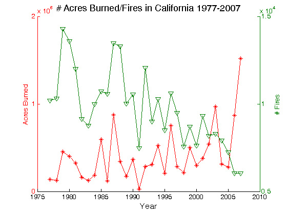
Forest fires have always been part of the natural cycle in forests. Some genera the Cyprus family of trees, such as the coastal redwood Sequoia species Sequoia sempervirens (the world’s tallest trees) and the Giant Sequoia Sequoiadendron giganteum in the Sierra Nevada range (the world’s largest tree by volume) even depend on low-intensity fire for their propagation. However, many large intense fires have now become the norm in these regions. The primary reason for these large fires has been due to fuels accumulation, weather events, fire suppression, arson during extreme weather events, and the lack of moisture in fuels due to decreased rainfall and snow pack accumulation. In the Sierra, this is compounded by the fact that the snow pack starts to melt earlier in the season and creates a longer dry season. Over the past 30 years, there has been a trend towards fewer wild fires per year, while the total area burned has remained somewhat constant or even trended upwards by a small degree (See Figure 1).Thus, the increase in fuels and plant stress has greatly increased the risk posed to sensitive habitat, and human lives and property; these areas are respectively called Critical Wildland Habitat and Wildland Urban Interface lands, or WUI lands.
A few years ago, the spread of the Big Fire in the San Bernardino Mountains was attributed to the wind and the high density of trees that had been attacked by the pine bark beetle. The infestation was aided by trees under stress due to drought conditions. The start of the fire was of suspicious origin during a hot dry weather event. From just this one example, it can be seen that the fire size was due to a number of conditions, each of which contributed to the severity of the event. Although many of the large fires in southern California can be attributed to arson, downed power lines during wind events and lightning strikes (in northern California) are also significant causes. The main issue is that the total area burned, numbers of fires, etc. are functions of many variables, each which can be significant at least some of the time. Overall, the complexity of the problem has led to a battle of what is more significant: fire suppression over decades, changing climate, and several others.
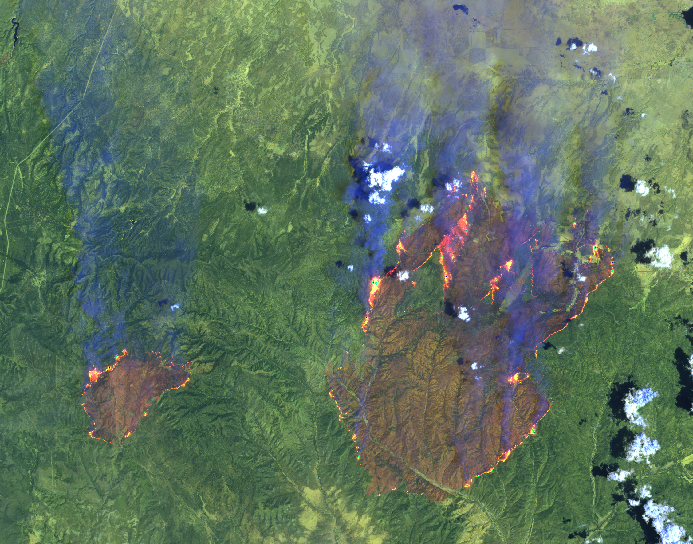
Even though fire suppression has long been accused of being a major cause of large conflagrations, the amount and condition of the fuel that is burned is perhaps the most significant factor. A few years ago, two fires in Arizona (The Rodeo and Chedeski fires) burned out of control and eventually merged into an extremely large fire, most of which was concentrated on Navajo and Forest Service lands. Patterns of fire severity and speed could be easily discerned from aircraft flyovers and from satellite imagery. The bottom line was that the fire was fast moving and severe in those areas with high levels of fuel, and slower and less severe when understory fuels and tree density was lower. Without knowing beforehand, it was possible to identify where the Navajo nation had thinned the forest, and where fuels treatments had been applied by the Forest Service by observing satellite imagery of the fire. Mark Finney of the USFS fire lab in Missoula also demonstrated this phenomenon using fire spread models for forested areas. He was able to show that fire acted as if an entire region was treated when a smaller distributed pattern of treatments were applied. Thus, some treatment could help protect the entire forest from a catastrophic fire. From this, the US Forest Service began a new program that is directed by a team called the Fire Cadre. The Fire Cadre was tasked to plan spatially based fire treatments across the National Forest lands in California.
In order to reduce the intensity of forest fires and to protect these critical habitats and WUI lands, fuels removal must be performed. The Forest Service calls these fuels treatments SPLATs. SPLATs are Strategically Placed Area Treatments or Strategically Placed Landscape Area Treatments; both breakdowns of the SPLAT acronym are used interchangeably by the United States Forest Service (USFS) and in fire literature. However, in order for the US Forest Service to protect Critical Habitat and WUI lands, available resources must be utilized and applied optimally or near optimally.
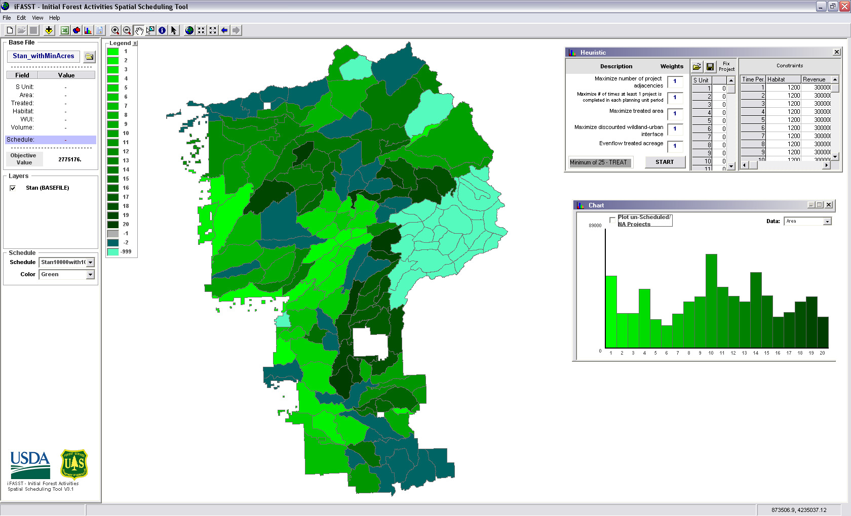
The need to reduce fire intensity while also staying within budget and effectively protecting Critical Habitat and WUI lands prompted the United States Forest Service to fund a grant project proposed by Klaus Barber, the Regional Analyst (Region 5) in Ecosystem Planning, and Bernie Bahro of the Fire Cadre. Former UCSB Geography graduate students, Dr. Jesse O’Hanley, Dr. Richard Middleton, Lisa Murawski, and Matthew Niblett, as well as Professor Richard Church, have aided them. Their proposal resulted in the creation of the Initial Forest Activities Spatial Scheduling Tool, or iFASST for short.
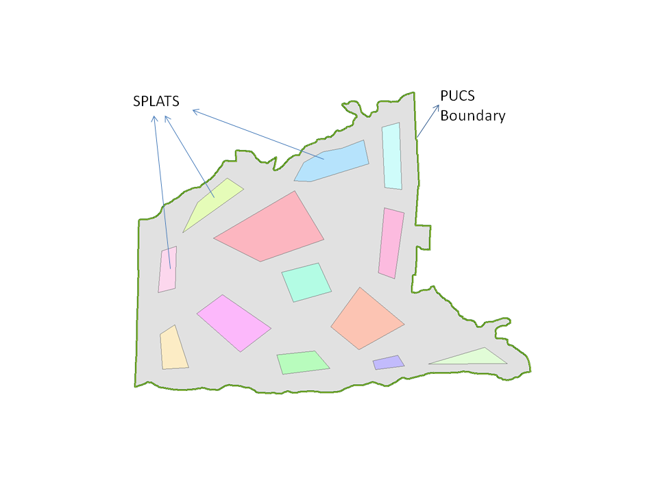
The iFASST, and subsequent Maintenance Forest Activity Spatial Scheduling Tool (mFASST) project, seeks to selectively treat units across an entire forest through fuels reduction techniques, such as mechanical fuels removal (rake up ground litter and remove areas of dense undergrowth), control burns, and selective logging where applicable, using a spatially based strategy that effectively treats the entire forest area without actually having to treat all of the forest area, following the “Finney Effect.” To do this, a planning area, or Planning Unit Containing Splats is utilized (See Figure 2). The Initial Forest Activities Spatial Scheduling Tool has been utilized throughout the Sierra Nevada Range, northwest California, and a few southern California forests. Forests in which these techniques have been applied have demonstrated that fire can be reintegrated into forests, burn less intensely, and keep fires to a manageable size.
The following article by Geography PHD student Matt Niblett was
prompted by an earlier news article, “UCSB Geography and Chaparral
Fires,” in which it was stated that "The national trend towards
increasing area burned is largely due to the unnatural accumulation of
fuels due to fire suppression, logging, and other factors." As Matt
points out, “the article implied that all logging is bad”: “there is
evidence that suggests selective logging actually reduces fire
intensity and size of fire.” Read on!
.jpg)