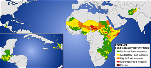
The mission of the Department of Geography’s Climate Hazard Group is to use “the UCSB Geography department’s strengths in statistical climatology, hydrology, GIS, remote sensing, and geostatistics to reduce the threat of flooding and famine in the developing world. The CHG works closely with governmental institutions (especially the United States Geological Survey (USGS) International Program) to improve the scientific research, capacity building, and application components of the USAID-funded Famine Early Warning System Network (FEWS NET). In addition to a research team at UCSB, the CHG employs scientists stationed in Africa, Central America, and Washingon, D.C., enabling us to quickly communicate new scientific developments and news of potential climate-related hazards. The CHG’s scientific focus is “geospatial hydroclimatology,” with an emphasis on the early detection and forecasting of hydroclimatic hazards related to food security droughts and floods. Basic research seeks an improved understanding of the climatic processes that govern drought and flood hazards in FEWS NET countries. We develop better techniques, algorithms, and modeling applications to use remote sensing and other geospatial data for hazard early warning.”
According to its web site, the UCSB Climate Hazards Group specializes in applying climatology to problems of food security: “We act as intermediaries between institutions specializing in forecasts, such as the International Research Institute for Climate Prediction and NOAA’s Climate Prediction Center (CPC), and users of climate forecast and monitoring data, such as the agronomists and economists evaluating food security for the Famine Early Warning System Network (FEWS NET). The CHG has evolved over the last 5 years as part of the ongoing collaboration between the USGS International Program and the University of California, Santa Barbara Geography Department. The current status of this evolution involves the production of existing CHG products for consumption via this website, and the development of new approaches to rainfall mapping, prediction, and evaluation.”
The CHG group is headed by Professor Joel Michaelsen and currently consists of two Associate Researchers (Dr. Chris Funk and Dr. Greg Husak), two Associate Specialists (Dr. Kathryn Grace and Dr. Park Williams), four Graduate Student Researchers (Frank Davenport, Laura Harrison, Michael Marshall, and Amy McNally), three Computer Network Technicians (Greg Ederer, Jon Hall, and Pete Peterson), and one undergraduate Student Assistant (Trevor Cunningham). The following material is taken from Chris Funk’s report (Funk, C., 2010, A Climate Trend Analysis of Kenya—August 2010: U.S. Geological Survey Fact Sheet 2010-3074, 4 p):
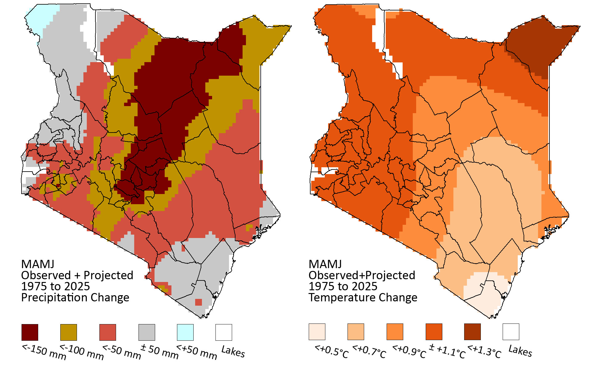
“This brief report draws from a multi-year effort by the United States Agency for International Development’s Famine Early Warning System Network (FEWS NET) to monitor and map rainfall and temperature trends over the last 50 years (1960–2009) in Kenya. Observations from seventy rainfall gauges and seventeen air temperature stations were analyzed for the long rains period, corresponding to March through June (MAMJ). The data were quality controlled, converted into 1960–2009 trend estimates, and interpolated using a rigorous geo-statistical technique (kriging). Kriging produces standard error estimates, and these can be used to assess the relative spatial accuracy of the identified trends. Dividing the trends by the associated errors allows us to identify the relative certainty of our estimates…Assuming that the same observed trends persist, regardless of whether or not these changes are due to anthropogenic or natural cyclical causes, these results can be extended to 2025, providing critical, and heretofore missing information about the types and locations of adaptation efforts that may be required to improve food security.
Conclusions:
- Long rains in central Kenya have declined more than 100 millimeters since the mid-1970s. This decline is probably linked to warming in the Indian Ocean, and seems likely to continue.
- The observed drying tendency is the opposite predicted by the 4th Intergovernmental Panel on Climate Change (IPCC ) assessment.
- A warming of more than 1° Celsius may exacerbate drying impacts, especially in lowland areas.
- The drying trends could particularly impact densely populated areas to the east, north, and north-west of Nairobi.
- Critical surplus crop growing areas in Central Kenya are threatened, and the amount of prime arable land could diminish substantially.”