According to Wikipedia, “crowdsourcing is the act of sourcing tasks traditionally performed by specific individuals to a group of people or community (crowd) through an open call. Jeff Howe established that crowdsourcing gathers those who are most fit to perform tasks, solve complex problems, and contribute with the most relevant and fresh ideas. For example, the public may be invited to develop a new technology, carry out a design task (also known as community-based design or “design by democracy” and distributed participatory design), refine or carry out the steps of an algorithm, or help capture, systematize, or analyze large amounts of data… With the increase of Web applications’ capabilities over the past two decades, the capabilities for crowdsourcing techniques have been greatly increased, and now the term often refers exclusively to Web-based activity. While the potential for Web-based crowdsourcing has existed for many years, it hasn’t been well implemented until more recently.”
Professor Mike Goodchild has been exploring the crowdsourcing of geographic information and recently gave a presentation on the subject as part of the UCSB Interdisciplinary Humanities Center’s “Public Goods” series. Titled “Maps as a Public Good: Crowdsourcing in Fire Emergencies,” his abstract stated that “Developments in Web technology have made it easy for the average citizen to provide information about events on the Earth’s surface. This information is especially valuable in time-critical situations, such as wildfires. After examples of the power of crowd-sourced geographic information, the presentation focuses on the role of the community in gathering and maintaining current information during fire emergencies in Santa Barbara. Volunteers have played key roles both in creating information, and in synthesizing it in the form of online maps and situation reports. The key issue of data quality is discussed.”
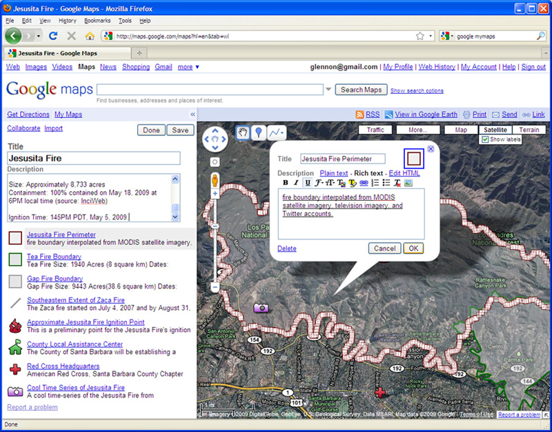
Goodchild emphasized the fact that crowdsourcing geographic information is simply volunteer GIS on a large scale. It has advantages and disadvantages in time-critical situations such as wildfires, and he illustrated both by using Santa Barbara’s May 2009 Jesusita Fire (which destroyed 80 homes over a period of 2 days and caused the evacuation of 14,735 people) as a case in point. The advantage of using community reports during that emergency was that information could be posted online instantaneously, whereas official media reports had to be verified first, creating a time lag. This disparity is illustrated by the fact that an online real-time map of the fire synthesized by members of the UCSB Department of Geography and the local community received nearly 600,000 hits during the Jesusita Fire emergency.
The disadvantage, of course, is that such asserted information carries the risk of error, which can be critical in an emergency. However, as Goodchild pointed out, the likelihood of error generally follows Linus’s Law, which postulates that the more sources of input that are used, the more likely it is that the input will be accurate. In emergencies, confidence is based in part on the number of identical reports and by comparing purported facts with simple geographic rules, such as the tendency of fires to advance downwind. Mike concluded his presentation by pointing out that “It is clear, however, that society has now entered a new era where geographic information will not only be used by all, but created by all, or at least by a dense and distributed network of observers. This leads to an entirely new vision for Digital Earth, one of a dense network of distributed, intelligent observers who are empowered to create geographic information, and particularly the types of geographic information that remote sensing and other large-scale acquisition systems are unable to produce. Protocols and institutions will be needed to ensure that the result is as reliable and useful as possible.”
.jpg)