The following is a September 7, 2010 UCSB Press Release by the Office of Public Affairs titled “Size, Distribution of Termite Mounds Foretell Ecological Shifts from Climate Change in Africa’s Savannas”:
“Scientists have discovered that the size and distribution of termite mounds in South Africa can be used to predict ecological shifts from climate change. The research is published in the advanced online edition of Nature Communications.
“In Southern Africa, as in most parts of the world, soil properties strongly influence vegetation patterns –– but most of the time we can only infer soil properties because we cannot dig everywhere,” said co-author Oliver Chadwick, professor of geography at UC Santa Barbara. “In this research, we were able to use the distribution of termite mounds to evaluate the controls on below-ground properties, and how their spatial differences affect plant distributions.”
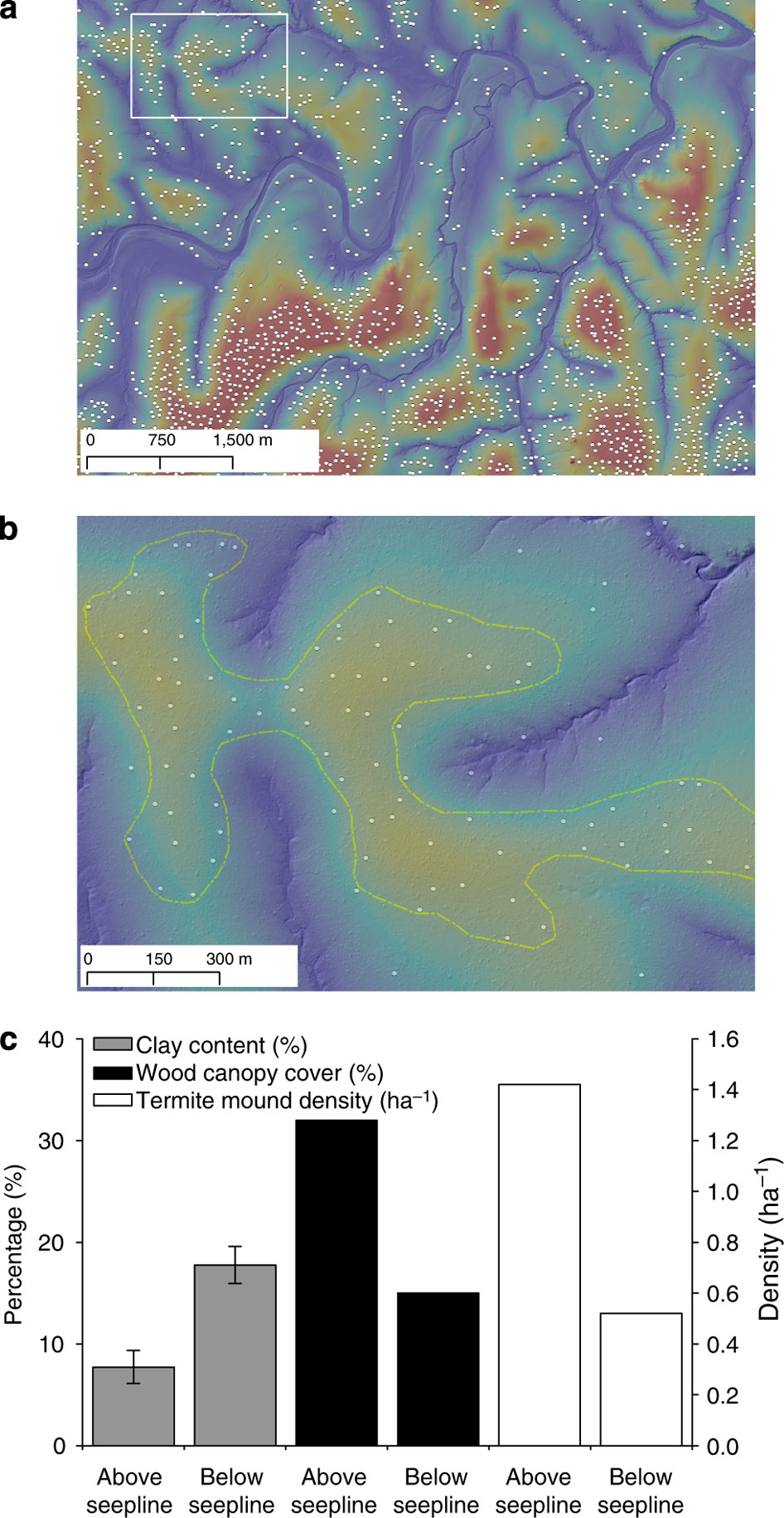
Mound-building termites in the study area of Kruger National Park in South Africa tend to build their nests in areas that are not too wet, nor too dry, but are well-drained, and on slopes of savanna hills above boundaries called seeplines. Seeplines form where water has flowed below ground through sandy, porous soil and backs up at areas rich in clay. Typically, woody trees prefer the well-drained upslope side where the mounds tend to locate, while grasses dominate the wetter areas down slope.
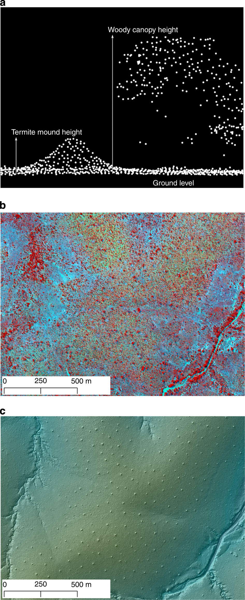
Using airborne imaging and structural analysis, scientists mapped more than 40,000 termite mounds over 192 square miles in the African savanna. They found that their size and distribution is linked to vegetation and landscape patterns associated with annual rainfall. The results reveal how the savanna terrain has evolved and show how termite mounds can be used to predict ecological shifts from climate change.
“These relationships make the termite mounds excellent indicators of the geology, hydrology, and soil conditions,” commented lead author Shaun Levick of Carnegie Institution’s Department of Global Ecology. “And those conditions affect what plants grow and thus the entire local ecosystem. We looked at the mound density, size, and location on the hills with respect to the vegetation patterns.”
According to the scientists, the advantage of monitoring termite mounds in addition to vegetation is that mounds are so tightly coupled with soil and hydrological conditions that they make it easier to map the hill slope seeplines. Furthermore, vegetation cover varies a lot between wet and dry seasons, while the mounds are not subject to these fluctuations.”
Abstract: “Global vegetation models predict the spread of woody vegetation in African savannas and grasslands under future climate scenarios, but they operate too broadly to consider hillslope-scale variations in tree–grass distribution. Topographically linked hydrology–soil–vegetation sequences, or catenas, underpin a variety of ecological processes in savannas, including responses to climate change. In this study, we explore the three-dimensional structure of hillslopes and vegetation, using high-resolution airborne LiDAR (Light Detection And Ranging), to understand the long-term effects of mean annual precipitation (MAP) on catena pattern. Our results reveal that the presence and position of hillslope hydrological boundaries, or seeplines, vary as a function of MAP through its long-term influence on clay redistribution. We suggest that changes in climate will differentially alter the structure of savannas through hydrological changes to the seasonally saturated grasslands downslope of seeplines. The mechanisms underlying future woody encroachment are not simply physiological responses to elevated temperatures and CO2 levels but also involve hydrogeomorphological processes at the hillslope scale.” The complete article (Shaun R. Levick, Gregory P. Asner, Oliver A. Chadwick, Lesego M. Khomo, Kevin H. Rogers, Anthony S. Hartshorn, Ty Kennedy-Bowdoin & David E. Knapp (2010) Regional insight into savanna hydrogeomorphology from termite mounds. Nature Communications, Volume 1, no. 65: doi:10.1038/ncomms1066) can be found here.