The following “News and Views” article, “Hydrology: Himalayan Groundwater” by Professor Bodo Bookhagen, is from Nature Geoscience (2012), doi:10.1038/ngeo1366, published online 10 January, 2012. Dr. Bookhagen notes that “the News & Views combines several observations that I have made during the past year, including conference visits and discussions with colleagues. Water in the form of rain, snow, and ice in the high Himalaya and Tibetan Plateau is vital for almost half of the world’s population. Because of increasing droughts, decreasing monsoon predictability, and increasing water demands, water stored in the form of snow and ice has been the focus of recent research activities. Last year, there were several conferences in SE Asia that specifically addressed water resources and combined research from the physical, social, and political sciences. An upcoming report by the National Academy of Science will look at changes in the water storage throughout High Asia at human-relevant timescales”:
Rivers draining the Himalaya provide vital resources for almost half of the world’s population. A combined model–data analysis suggests that the contribution of groundwater to the annual water budget in the central Himalaya may be substantial.
In the high Himalaya, rain, ice and snow are thought to control discharge of the large rivers. These streams flow across the Ganges plain south of the Himalaya and provide critical water resources for irrigation, hydropower, municipalities, recreation, and habitat. Increasing irrigation demands and decreasing river water quality have led to significant depletion of groundwater resources throughout the plains in India and adjacent countries, and have caused increased dependence on Himalayan water supplies. Yet our understanding of the timing and relative contribution of individual hydrologic components across the Himalaya is limited. Writing in Nature Geoscience, Andermann and colleagues estimate annual groundwater fluxes for Nepal and find that they are larger in volume than the contribution from ice- and snowmelt.
Himalayan water budgets and the state and fate of Himalayan glaciers have attracted considerable debate in both the scientific community and mainstream media. Himalayan glaciers are clearly thinning and retreating, but the signals of change are spatially complex. In addition, the behavior of summer monsoonal rainfall has been erratic during the past few decades, making it more difficult to predict available water resources. As a result, transient storage in the form of snow and ice has become a focus of attention.
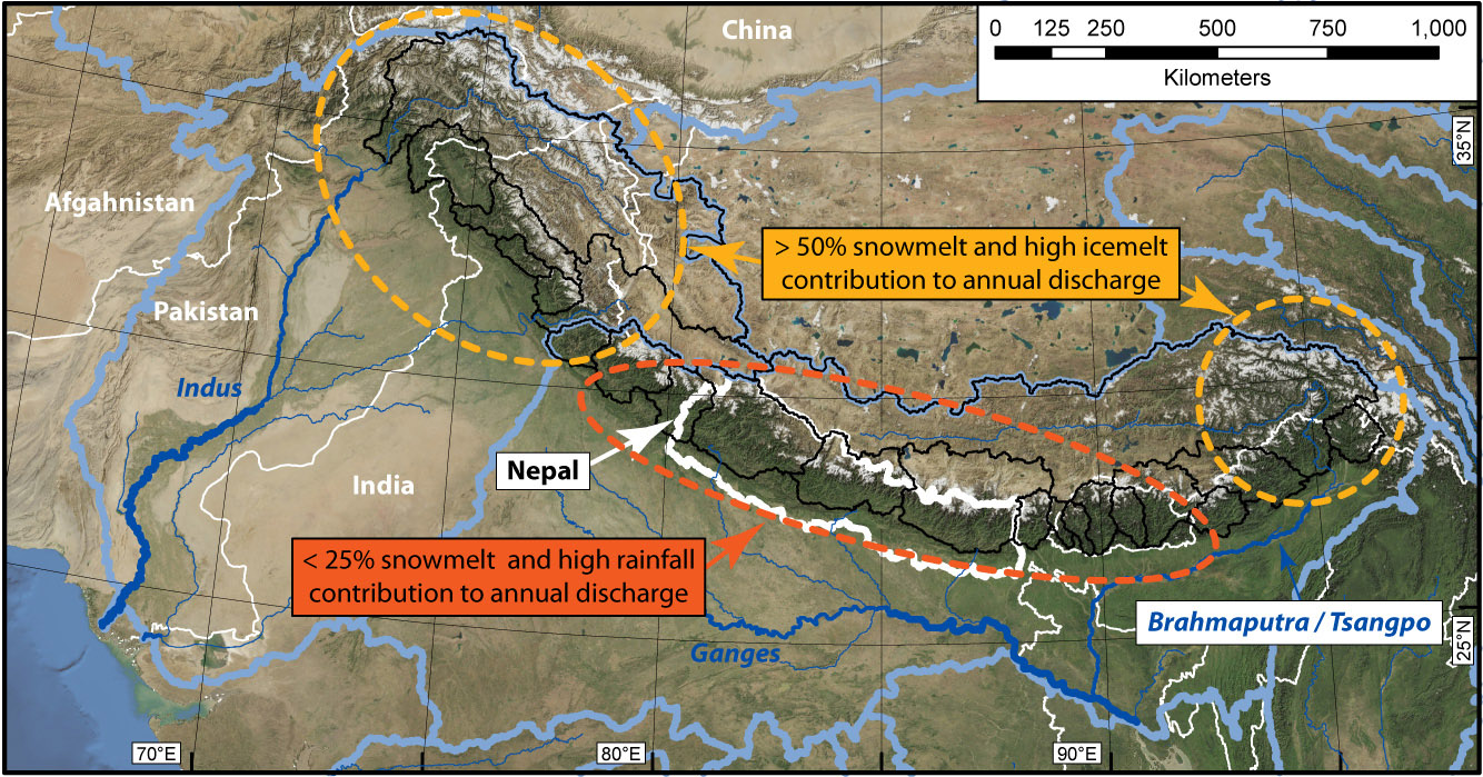
The relative contributions to Himalayan river discharge from the various components of the hydrologic cycle are uncertain. Nevertheless, the steep climatic contrast along the Himalayan mountain chain is likely to be reflected in the water regime. In northwest and far east Himalaya, more than 50% of the annual discharge comes from snow that falls during the winter westerlies. By contrast, the central Himalayan rivers generally receive less than ~25% of their annual discharge from snowmelt, and are instead fed mainly by summer monsoon rainfall. Glacial-discharge contributions in the high-elevation Himalaya are more complex, but the few existing mass–balance studies and studies measuring the seasonal waxing and waning of glaciers suggest a significant glacial contribution to discharge. Importantly, the release of water stored in the form of snow and ice is delayed. Snowmelt was found to be the most important water source in the pre-monsoon season from March to May, whereas rainfall and glacial melt become key contributors to river discharge during the summer.
Groundwater storage adds immense complexity to this picture of Himalayan hydrology, and it is notoriously difficult to measure, especially in mountainous terrain. Advances from satellite gravimetry in the gravity recovery and climate experiment (GRACE) have helped to quantify groundwater depletion in the plains of northwest India, but the spatiotemporal resolution of the current satellite system is too coarse to fully distinguish between groundwater, ice melt, and sedimentological and tectonic processes.
Andermann and colleagues have chosen a combination of daily rainfall and discharge measurements and hydrological modeling to quantify the groundwater contribution to central Himalayan rivers. They rely on a unique 30-year record that shows an intriguing behavior: river discharge at equal levels of daily rainfall is generally lower in the early than in the late monsoon season. They explain this discrepancy with the presence of a temporary subsurface storage system, such as a fractured basement layer with a depth of a few tens of meters. The storage system is re-charged in the early part of the rainy season and then slowly purged with a one-and-a-half-month time lag, so that discharges are higher during the late summer season.
Using a simple but effective hydrological model, the authors estimate the flow of water through the fractured basement as approximately six times the annual contribution from glacier- and snowmelt. Because rock type and geologic history affect basement fracturing, catchments with different lithologies, and degrees of glaciation were studied. Neither rock type nor glaciation seems to significantly affect the general discharge behaviour.
The work sheds light on a little-studied problem. Progress in determining and predicting water resources in the Himalaya has been hampered by a number of factors. The remoteness of the terrain makes it difficult to collect reliable hydrometeorological data sets. Some water management agencies lack the will to share data across international borders, and a general gap in the understanding of water storage and transport in steep terrain makes it difficult to place available data in a broader context.
Nevertheless, the hydrologic model used by Andermann and colleagues does have some drawbacks. It only accounts for snowmelt waters and not for the melting of glacial ice and permafrost processes, which are likely to be important discharge contributions during the late summer. Furthermore, with a model based on mean monthly values, it is difficult to establish the infiltration behaviour of relatively short, but strong, monsoon storms. Finally, but beyond the scope of this study, the region’s transient water storage in soils, regolith and plants has not yet been established, but may locally provide considerable capacity, especially in the heavily vegetated parts of the Himalaya.
Andermann and co-authors provide compelling evidence that a significant time lag exists between rainfall and runoff. This lag could have important implications for the management of natural hazards and water in the region. For example, hydropower generation depends on a steady discharge and groundwater is an important contributor during the late summer monsoon season, when rainfall amounts are decreasing. Furthermore, future studies assessing landslide risk will have to look at the spatiotemporal distribution of water in the fractured basement layer. Once this subsurface reservoir is filled (for example, by large amounts of rainfall during the early monsoon season), landslide potential will be higher because of increased pore-water pressures.
The findings presented by Andermann and colleagues on central Himalayan hydrology require a significant reassessment of seasonal water budgets and water resource management in the region. As a result of climate change, temperatures are expected to increase over the next few decades, and both rainstorms and droughts have been projected to become more intense. Efficient adaptation to such changes, and proper allocation and preservation of water resources, will be possible only with a detailed understanding of the individual hydrologic components.