Remember Paul Sutton? Currently a Professor of Geography at the University of Denver, Paul was a graduate student at UCSB from 1992 to 1999. He received an MA in Geography in 1995, an MA in Statistics in 1997, and a PhD in Geography in 1999, and his dissertation, “Census from Heaven: Estimation of Human Population Parameters using Nighttime Satellite Imagery,” reflects his continued interest in the dynamics of human-environment relations.
“I took a position in the Geography Department at the University of Denver in the Fall of 1999 and have been here since then. I have many interests spanning much of geography but ranging into ecology, economics, and philosophy. Most of my research focuses on applied issues associated with the Human-Environment-Sustainability problematic. I do a great deal of work with nighttime satellite imagery derived from the Defense Meteorological Satellite Program’s Operational Linescan System (DMSP OLS). Data products derived from DMSP OLS imagery are being used to map and estimate human population distribution, energy consumption, economic activity, urban extent, CO2 emissions, Ecological Footprints, and more. The tools needed to engage in this research are remote sensing, geographic information analysis, and statistics. I also am interested in the development of the discipline of ecological economics. I use my expertise in GIS and spatial data analysis in collaborations with economists and ecologists to make spatially explicit valuations of ecosystem services” (source).
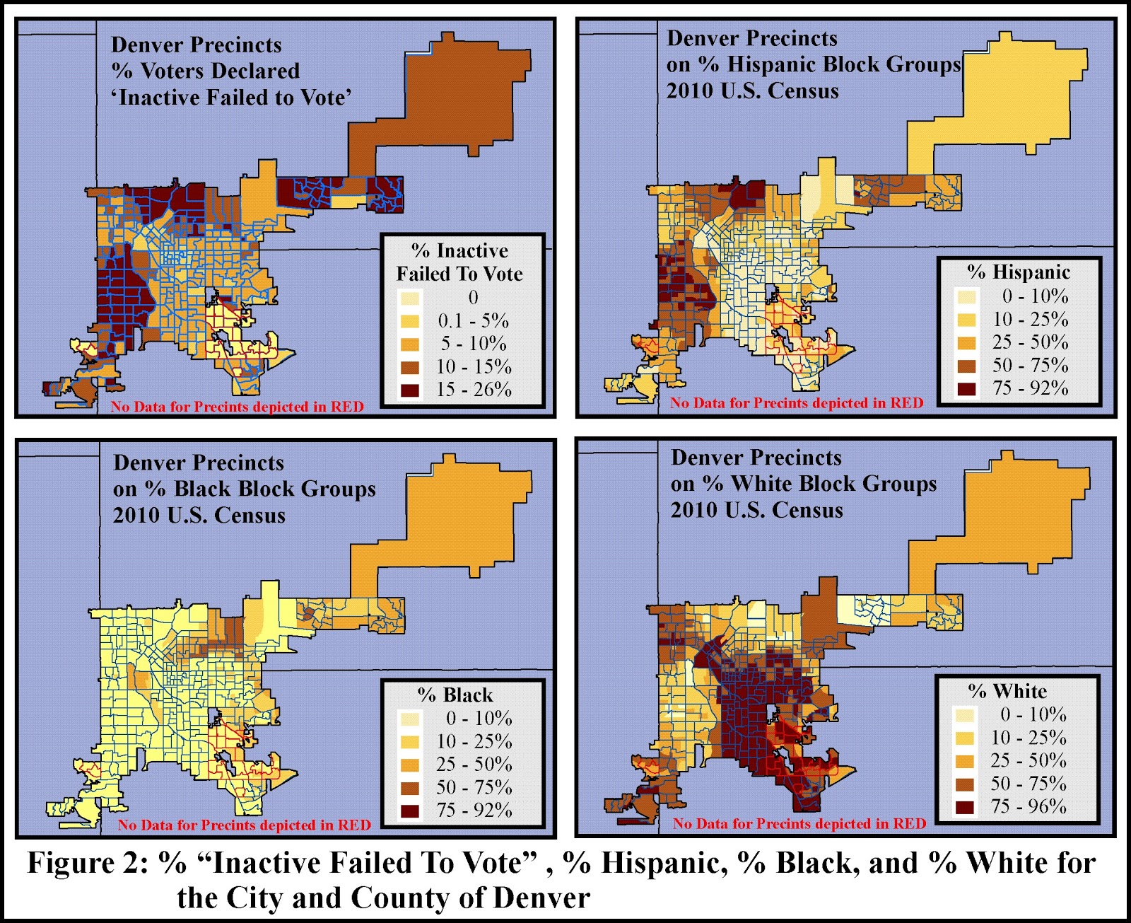
Paul recently collaborated with a colleague, Seth Masket (Associate Professor of Political Science, University of Denver), on mapping and assessing voter suppression in the state of Colorado. In a blog dated February 18, titled “Mischiefs of Faction: Reflections on Parties and their Place in Politics,” Dr. Masket describes his efforts as an expert witness to help determine the probable results of the Colorado Secretary of State’s announcement in late 2011 that the state’s mail-in ballots would henceforth only be sent out automatically to those who were “active” voters, meaning they had voted in the last general election.
“With the help of University of Denver geographer Paul Sutton, I compared voting precincts in Denver, Pueblo, and throughout the state based on their racial breakdowns and on the percent of voters listed as IFTV (“Inactive – failed to vote,” meaning they did not vote in the last general election) […] the trend is quite consistent: the higher concentration of a racial minority group within a precinct, the more people in that precinct who did not vote in the previous general election, and the more people who would be deprived of an automatic mail-in ballot […]Based partially on this analysis, the judge in the case ruled against the Secretary of State, and the change in mail-in voter policy is not being implemented. But given partisan voting patterns among different racial groups, it’s not hard to imagine how this would have played out electorally had it been enforced.”