In The Devil’s Dictionary (1911), Ambrose Bierce defined “boundary” as follows: “BOUNDARY, n. In political geography, an imaginary line between two nations, separating the imaginary rights of one from the imaginary rights of the other.”
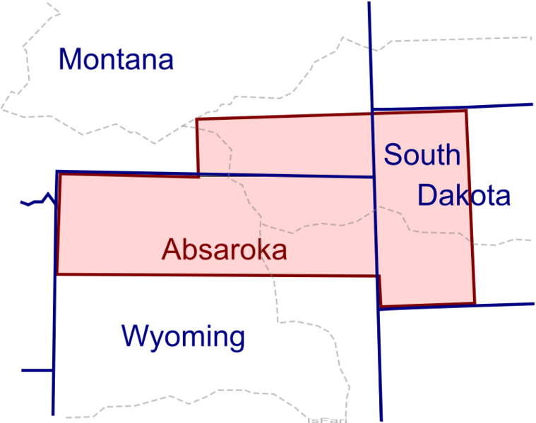
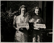
Absaroka (pronounced “ab-SOR-ka” – from the Crow Indian word for “children of the large-beaked bird”) almost became a part of the USA in 1939 when ranchers in parts of Wyoming, Montana, and South Dakota tried to form their own state. They were all opposed to Roosevelt’s “New Deal,” and, while details are sparse, evidently an ex-baseball player appointed himself governor and began hearing writs of grievance, license plates were distributed, a “Miss Absaroka 1939” was crowned, and the king of Norway even paid a state visit (albeit unwittingly). “On another continent or in another era, all this might have qualified Absaroka for total independence. But alas, in 1930s America, with its by then well-established administrative divisions, even statehood proved to be beyond the Absarokans’ grasp. And the fledgling state might have faded from history entirely, had it not been recorded by the Federal Writers’ Project, eager to include it as an example of cowboyin’ couleur locale” (http://strangemaps.wordpress.com/).
In his Geog 5 class, People, Place, and Environment, Dan Montello likes to point out that “invented countries exist mostly in the minds of their citizens. But then real countries are essentially the same — shared notions about how to divide control of the world’s surface and people. In a sense, all you have to do to establish a state is stake your claim and then convince the rest of the world to accept its legitimacy. There are several principles of international law that have been established to determine state sovereignty, but recognition by other states is the main one.” And that’s where the US state of Absaroka came absolutely unstuck – as did the State of Deseret, the State of Franklin, the State of Jefferson, the State of Kanawha, the State of Lincoln, the State of Sequoyah, the State of Superior, and the State of Westmoreland. And don’t forget that there have been at least 27 attempts to split up the state of California since it acquired statehood in 1850!
For more on this and similar subjects , see the following:
- http://en.wikipedia.org/wiki/Absaroka
- http://strangemaps.wordpress.com/
- http://www.nytimes.com/2008/07/24/us/24wpa.html?ref=us
Article by Bill Norrington