The following is an article by Robert Sanders, writing for UC Berkeley Media Relations on May 14, 2014 and with the title above:
Winter rains and summer groundwater pumping in California’s Central Valley make the Sierra Nevada and Coast Ranges sink and rise by a few millimeters each year, creating stress on the state’s earthquake faults that could increase the risk of a quake. Gradual depletion of the Central Valley aquifer because of groundwater pumping also raises these mountain ranges by a similar amount each year – about the thickness of a dime – with a cumulative rise over the past 150 years of up to 15 centimeters (6 inches), according to calculations by a team of geophysicists.
While the seasonal changes in the Central Valley aquifer have not yet been firmly associated with any earthquakes, studies have shown that similar levels of periodic stress, such as that caused by the motions of the moon and sun, increase the number of microquakes on the San Andreas Fault, which runs parallel to the mountain ranges. If these subtle seasonal load changes are capable of influencing the occurrence of microquakes, it is possible that they can sometimes also trigger a larger event, said Roland Bürgmann, UC Berkeley professor of earth and planetary science at UC Berkeley.
“The stress is very small, much less than you need to build up stress on a fault toward an earthquake, but in some circumstances such small stress changes can be the straw that broke the camel’s back; it could just give that extra push to get a fault to fail,” Bürgmann said. Bürgmann is a coauthor of a report published online this week by the journal Nature. The study, based on detailed global positioning satellite (GPS) measurements from California and Nevada between 2007 and 2010, was led by former UC Berkeley postdoctoral fellows Colin Amos, now at Western Washington University, and Pascal Audet, now of the University of Ottawa. The detailed GPS analysis was performed by William C. Hammond and Geoffrey Blewitt of the University of Nevada, Reno.
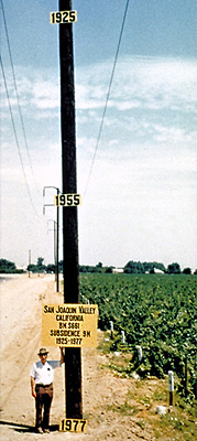
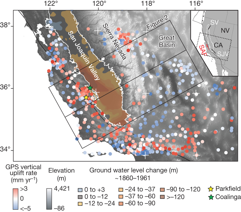
Water has been pumped from California’s Central Valley for more than 150 years, reducing what used to be a marsh and extensive lake, Tulare Lake, into fertile agricultural fields that feed the world. In that time, approximately 160 cubic kilometers (40 cubic miles) of water was removed – the capacity of Lake Tahoe – dropping the water table in some areas more than 120 meters (400 feet) and the ground surface 5 meters (16 feet) or more. The weight of water removed allowed the underlying crust or lithosphere to rise by so-called isostatic rebound, which has raised the Sierra probably as much as half a foot since about 1860, Bürgmann said.
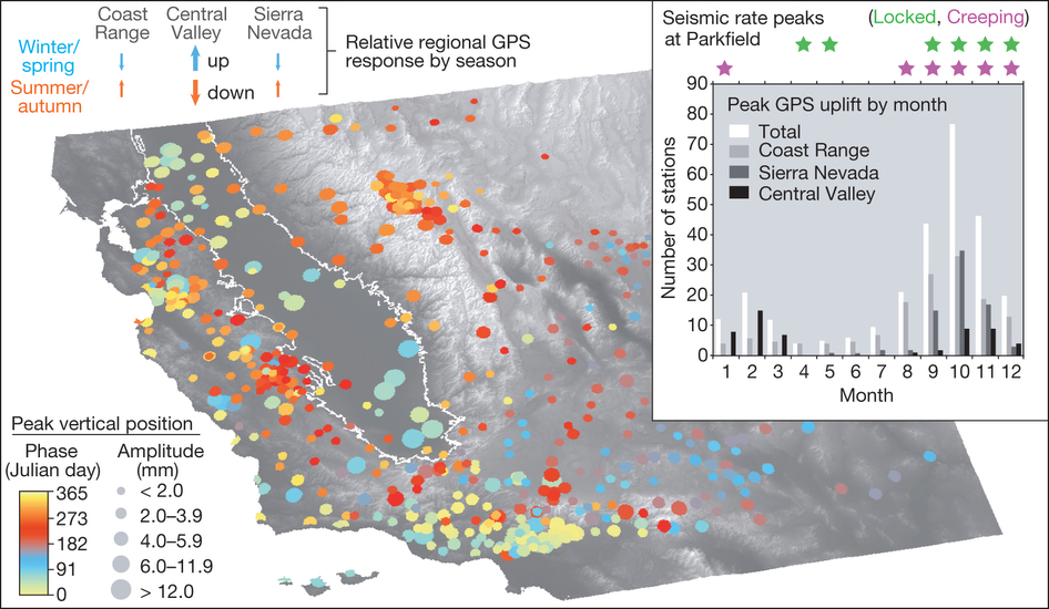
The same rebound happens as a result of the state’s seasonal rains. Torrential winter storms drop water and snow across the state, which eventually flow into Central Valley streams, reservoirs and underground aquifer, pushing down the crust and lowering the Sierra 1-3 millimeters. In the summer, water flow through the delta into the Pacific Ocean, evaporation and ground water pumping for irrigation, which has accelerated in the past few years because of a drought, allows the crust and surrounding mountains to rise again.
Bürgmann said that the flexing of Earth’s crust downward in winter would clamp the San Andreas Fault tighter, lowering the risk of quakes, while in summer the upward flexure would relieve this clamping and perhaps increase the risk. “The hazard is ever so slightly higher in the summer than in the wintertime,” he said. “This suggests that climate and tectonics interact; that water changes ultimately affect the deeper Earth too.”
Millimeter-precision measurements of elevation have been possible only in the last few years, with improved continuous GPS networks – part of the National Science Foundation-funded Plate Boundary Observatory, which operates 1,100 stations around the western U.S. – and satellite-based interferometric synthetic aperture radar (InSAR). Synthetic aperture radar is a form of radar in which phase information is used to map elevation.
These measurements revealed a steady yearly rise of the Sierra of 1-2 millimeters per year, which was initially ascribed to tectonic activity deep underground, even though the rate was unusually high, Bürgmann said. The new study provides an alternative and more reasonable explanation for the rise of the Sierra in historic times.
“The Coast Range is doing the same thing as the Sierra Nevada, which is part of the evidence that this can’t be explained by tectonics,” he said. “Both ranges have uplifted over the last few years and they both exhibit the same seasonal up and down movement in phase. This tells us that something has to be driving the system at a seasonal and long-term sense, and that has to be groundwater recharging and depletion.”
In response to the current drought, about 30 cubic kilometers (7.5 cubic miles) of water were removed from Central Valley aquifers between 2003 and 2010, causing a rise of about 10 millimeters (2/5 inch) in the Sierra over that time. After the new results were shared with colleagues, Bürgmann said, some geologists suggested that the state could get a better or at least comparable inventory of available water each year by using GPS to measure ground deformation instead of measuring snowpack and reservoir levels. (Reference: Uplift and seismicity driven by groundwater depletion in central California. Colin B. Amos, Pascal Audet, William C. Hammond, Roland Bürgmann, Ingrid A. Johanson & Geoffrey Blewitt. Nature (2014). doi:10.1038/nature13275.)


