Early Warning Science Battles Diminishing Agricultural Capacity and Climate Change in the Race for a Food Secure Africa (contributed by Geography Assistant Researcher Chris Funk).
Editor’s note: Dr. Chris Funk has been an Assistant Researcher for the Climate Hazard Group for 4 years, specializing in applied climatology, rainfall estimation, and agricultural early warning. Other members of the team include Saud Amer, Greg Husak, Diego Pedreros, Michael Marshall, Tamuka Magadazire, Lorena Aguilar, Alkhalil Adoum, and Gideon Galu, all under the aegis of Geography Professor Joel Michaelsen. The group routinely collaborates with Jim Verdin, Jim Rowland, and other USGS scientists. Saud Amer oversees international projects, and Greg Husak is project lead on all remote sensing projects.
As westerners, we often take our wealth for granted, not realizing that there are millions of people who consider a dollar a day a good wage, if they can get it. On half acre farms, with hand tools and poor soil, the world’s poorest families struggle to eke out an existence each year. They often fail. Eight hundred million people face dramatic food shortages each year (Food and Agriculture Organization, Food Insecurity in the World, 2005), and hunger and poverty drive a cycle of deprivation that accounts for more than half of all child deaths. One out of every six countries in the world is facing food shortages because of severe droughts that could become semi-permanent due to climate change (http://www.guardian.co.uk/international/story/0,,1517746,00.html). The root causes of hunger are legion: rapid rural population growth, poor agricultural practices, limited market access, crop subsidies in Europe and the U.S., poor governance, and drought. If we address these issues, we can eradicate chronic hunger in twenty years. If we ignore these issues, the number of chronically hungry families will double or treble over the next 20 years. As geographers, we can contribute by extending our capacity to monitor and predict the hydro-climatic, environmental, and social circumstances that lead to famine. This is the goal of famine early warning science.
The famine early warning story begins in the early 1970s. A persistent multi-year drought struck Africa. This drought was responsible for 100,000 deaths in the Sahel and 200,000 deaths in Ethiopia, and was soon followed by drought in 1983-1985 that saw deaths in Ethiopia estimated from 400,000 to 1 million. These large-scale famines shocked the world and pointed up the tragic lack of timely information that might serve to head off human suffering of huge proportions. Responding to the concern of the American people, the U.S. Congress called on the United States Agency for International Development to create the Famine Early Warning System (FEWS) in 1985. UCSB involvement with FEWS began in 1997 and led to establishment of cooperative agreements between the U.S. Geological Survey (USGS) and UCSB for further research in hydroclimatic monitoring, analysis, and forecasting for Africa and Central America. In the fall of 2002, the Climate Hazard Group (CHG) was established at UCSB to facilitate links between the International Program at the USGS EROS Data Center; five USGS-affiliated field scientists in Niger, Gabarone, Nairobi, and Guatemala; a coordinating scientist in Washington (Saud Amer); and a team of five research scientists at UCSB led by Geography Professor Joel Michaelsen. The Climate Hazard Group specializes in looking at the climate-related components of food-security through the lens of geography, sensitive to the context created by societal factors.
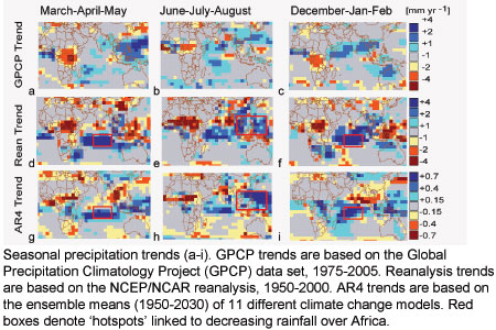
In 2005, CHG research identified links between warming in the southwest Indian Ocean and persistent multi-year drought events in eastern Africa and, especially, Ethiopia. This work suggested that global warming creates drought in Africa, undermining development efforts. Last year, 23 African countries faced serious food shortages, with civil strife and adverse weather playing dominant roles. The British Royal Academy incorporated the CHG’s work into their appeal to G8 ministers advocating effective reductions of greenhouse gas emissions. In 2006, this examination was expanded to encompass 19 food-insecure countries in western, southern, and eastern Africa. 132 climate change simulations from the 4th Intergovernmental Panel on Climate Change (IPCC) assessment report were also examined. The results of these analyses can be summarized briefly:i) Statistical analysis of 132 climate change simulations suggests that greenhouse emissions have and will cause increased precipitation in areas of the Indian-Pacific Ocean. This oceanic precipitation is likely tied to drought in sub-Saharan Africa.
ii) Declining per capita agricultural capacity has and will likely lead to increasing food aid needs in sub-Saharan Africa, while observed and IPCC-simulated rainfall totals suggest that drought plays a significant (but not dominant) role; modest increases of per capita production (~2 kg of food per year per person), however, could quickly halve food aid needs in Africa.
Evaluation of the IPCC simulations substantiated our 2005 claim that greenhouse warming in the Indian Ocean (Fig. 1) may be linked to drought in Africa. Most climate models concur that the southern Indian and western Pacific will continue to see substantial increases in sea surface temperatures and precipitation. Empirical observations and theoretical Rossby wave relationships both suggest that this oceanic precipitation has and will reduce rainfall over parts of semi-arid Africa. This implies in turn that the substantial post-1960s and post-1980s African drying tendencies were at least aggravated, if not caused by, anthropogenic climate change. Similar decreases appear likely over the next 30 years.
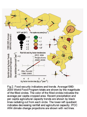
Further analysis has quantified the relative impact of rainfall deficits on food aid requirements (Fig. 2). In general, it appears that rainfall deficits account for about one third of food aid needs in semi-arid Africa. Per capita agricultural capacity (roughly the amount of cropped area per person) accounts for two-thirds. Both rainfall and per capita cropped area are likely to continue decreasing. Since 1980, the population of food-insecure Africa has doubled, cropped area has increased by 1½ times, rainfall declined by ~15%, and typical annual food aid totals increased by 2½ . Our modeling suggests a continuance of 1980-2000 trends will result in about a 70% increase in food aid needs by the 2020s.
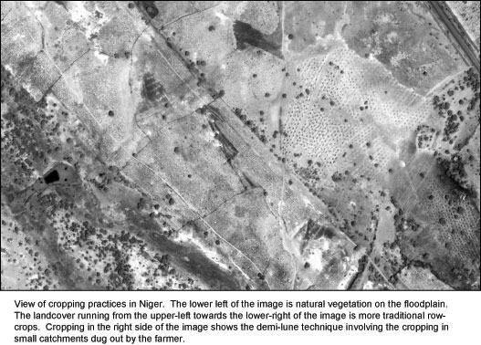
On the other hand, modest increases in agricultural productivity could quickly offset the negative impacts of climate change. Domestic food production in Africa is much greater than food aid totals. Africa feeds itself, almost. Fairly small increases in per capita agricultural productivity could make Africa food secure. Better monitoring and satellite observations can assist in this goal by guiding more effective policy. The CHG contributes to this goal in several exciting ways: We support the monitoring and training activities of 5 US Geological Survey (USGS) field scientists; we take advantage of the new generation of high resolution earth orbiting satellites to make accurate and timely assessments of cropped area (Fig 3) and crop production; and we work with USGS and NASA collaborators to merge climate monitoring and forecast systems. We hope that these research efforts will help us navigate wisely through the next few pivotal decades.


