The recent “snowball express” in much of Europe and the U.S. that shut down dozens of major airports over the holidays has left many Westerners questioning the concept of global warming. After all, it snowed on Christmas Day in parts of the U.S. South for the first time since right after the Civil War, six U.S. states declared states of emergency, 4,000 U.S. flights were canceled, and, gasp, a pro football game had to be postponed.
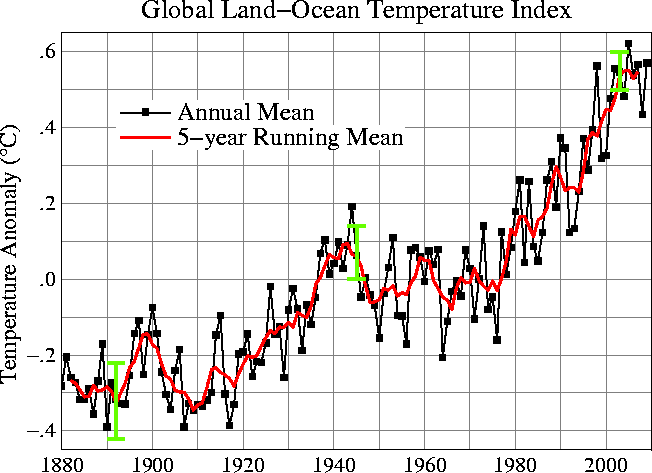
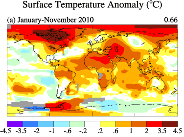
Warming? You’ve got to be joking. However, the Japan Meteorological Agency (JMA), in conjunction with several other international weather organizations, concludes that 2010 has been, at the very least, the second warmest year since reliable weather records began in 1880, and that 2010’s combined land and sea surface temperature was 0.65 degrees Fahrenheit warmer than the 1971-2000 average. Despite the brutal winter weather in the West, 2010 was a year of heat waves, with record temperatures set in 17 countries. Indeed, as JMA points out, 2010 actually may end up being the warmest year since records began, insofar as its value for the global average surface temperature in 2010 is subject to change because, at the time of its announcement, it was a preliminary result based on temperature observations for the period of January to November in 2010. Furthermore, JMA stated that the average 2010 temperature over land is expected to become the warmest record. Final results are scheduled to be released in February 2011.
“Analysis of climate records indicates that the nearly unprecedented warmth, when averaged globally, has actually shifted weather patterns at high latitudes, bringing an Arctic chill to Europe and the eastern United States. While this concept may seem counterintuitive, the last two months of below-normal temperatures in Europe have been sandwiched between the near-record late autumn warmth of northern Canada/Greenland and a broad stretch of central Asia and Siberia. This has locked the jet stream away from a pattern that normally brings Europe mild air from the mid-Atlantic. NASA says that, similar to last winter, a blocking weather pattern ‘allowed cold air from the Arctic to penetrate all the way into Europe, eastern China, and Washington, D.C.’ But perhaps the most driving influence in the new Arctic atmospheric configuration is the record melting of the polar ice cap in recent years. This has allowed the newly uncapped Arctic Ocean to radiate its heat into the atmosphere more easily, fueling large-scale changes in the way the air above responds to the winter months” (source).
In a recent paper coauthored by James Hansen in Reviews of Geophysics titled “Global surface temperature change,” the authors state: “We note in our paper that the few years just prior to 2009-2010, with low Arctic sea ice, did not produce cold winters in Europe. The cold winter of 2009-2010 was associated with the most extreme Arctic Oscillation in the period of record… 7 of the last 10 European winters were warmer than the 1951-1980 average winter, and 10 of the past 10 summers were warmer than climatology. The average warming of European winters is at least as large as the average warming of summers, but it is less noticeable because of the much greater variability in winter. Finally, we point out the anomalous summer warmth in 2003 and 2010, summers that were associated with extreme events centered in France and Moscow. If the warming trend that is obvious continues, as is expected if greenhouse gases continue to increase, such extremes will become common within a few decades” (source).