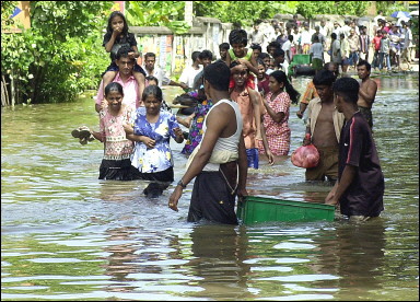
Asia was literally swamped by last year’s monsoonal flooding, with Pakistan being hardest hit – over one-fifth of Pakistan’s total land area ended up underwater, about 2,000 people were killed, and the floods directly affected about 20 million people. Torrential summer rains killed over 800 people and displaced millions in China. In May 2010, Poland’s Prime Minister described the country’s flooding as “the worst natural disaster in the nation’s history.” Ongoing floods that have ravaged Australia’s northeast and swamped a major city in recent months could be the country’s most expensive natural disaster ever. Brazil’s flash floods and mudslides in recent weeks have claimed over 800 lives and are considered the deadliest natural disaster in the country’s history. Torrential rain since December has triggered major flooding in the Philippines, leaving over 70 people dead, 453,000 displaced, and 1.2 million people affected. The rain in Sri Lanka in recent weeks has been the heaviest in nearly 100 years of record keeping, and the resulting flooding has left over 50 dead, over 3 million affected, and thousands in refugee camps. And the list goes on, as does the flooding.
“The year 2011 has begun with a remarkable number of high-impact floods world-wide, and much of the blame for this can be placed on the current La Niña event occurring in the Eastern Pacific. NOAA’s Climate Prediction Center currently puts the La Niña event in the “strong” category, and whenever a La Niña or El Niño event reaches the strong category, major perturbations to global weather patterns occur. This typically results in record or near-record flooding in one or more regions of the globe. When one combines the impact of La Niña with the increase of global ocean temperatures of 0.5°C (0.9°F) over the past 50 years, which has put 4% more water vapor into the atmosphere since 1970, the result is a much increased chance of unprecedented floods. A 4% increase in atmospheric moisture may not sound like much, but it turns out that precipitation will increase by about 8% with that 4% moisture increase. Critically, it is the extreme rainfall events that tend to supply the increased rainfall. For example, (Groisman et al., 2004) found a 20% increase in very heavy (top 1%) precipitation events over the U.S. in the past century, and a 36% rise in cold season (October – April) “extreme” precipitation events (those in the 99.9% percentile–1 in 1000 events. These extreme rainfall events are the ones most likely to cause floods” (source).
Closer to home, 2010 saw serious flooding in parts of the U.S., most notably from northern Arkansas to central Tennessee. The early May event was rated as a thousand-year flood (a flood given 0.1 percent chance of occurring) by the National Weather Service and caused an estimated $2 billion in damage. What if a similar event occurred in California? That’s what U.S. Geological Survey scientists sought to illustrate by developing a weather scenario in which California could be inundated by storms capable of producing up to 10 feet of rain. Their report, released January 13-14, warned that such an event would result in widespread flooding that would cause roughly $300 billion in damage:
The “ARkStorm Scenario,” prepared by the U.S. Geological Survey and released at the ARkStorm Summit in Sacramento on Jan. 13 – 14, combines prehistoric geologic flood history in California with modern flood mapping and climate-change projections to produce a hypothetical, but plausible, scenario aimed at preparing the emergency response community for this type of hazard. The USGS, the Federal Emergency Management Agency and the California Emergency Management Agency convened the two-day summit to engage stakeholders from across California to take action as a result of the scenario’s findings, which were developed over the last two years by more than 100 scientists and experts.
“The ARkStorm scenario is a complete picture of what that storm would do to the social and economic systems of California,” said Lucy Jones, chief scientist of the USGS Multi-Hazards Demonstration Project and architect of ARkStorm. “We think this event happens once every 100 or 200 years or so, which puts it in the same category as our big San Andreas earthquakes. The ARkStorm is essentially two historic storms (January 1969 and February 1986) put back to back in a scientifically plausible way. The model is not an extremely extreme event.”
Jones noted that the largest damages would come from flooding — the models estimate that almost one-fourth of the houses in California would experience some flood damage from this storm. “The time to begin taking action is now, before a devastating natural hazard event occurs,” said USGS Director, Marcia McNutt. “This scenario demonstrates firsthand how science can be the foundation to help build safer communities. The ARkStorm scenario is a scientifically vetted tool that emergency responders, elected officials and the general public can use to plan for a major catastrophic event to help prevent a hazard from becoming a disaster.”
George Santayana: “Those who cannot remember the past are condemned to repeat it”
Article by Bill Norrington


.png)
