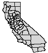
 Counties
of California. Metadata: text
or html
Counties
of California. Metadata: text
or html
Coverages and Grids available
Metadata describing where these are from, the map projection, horizontal and vertical datum, and any other pertinent information are provided, and should be downloaded with the datasets.
Counties
of California. Metadata: text
or html
 Outlineof
the Los Olivos 7.5 min Quadrangle, where Sedgwick is located. Metadata:
text or html
Outlineof
the Los Olivos 7.5 min Quadrangle, where Sedgwick is located. Metadata:
text or html
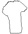 Sedgwick
Ranch property boundary (approximate dimensions, digitized to match the
DOQ). Metadata: text
or html
Sedgwick
Ranch property boundary (approximate dimensions, digitized to match the
DOQ). Metadata: text
or html
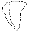 Major watersheds
contained within Sedgwick Reserve (Lisque Creek on left, Figueroa Creek on right).
Metadata: text or html
Major watersheds
contained within Sedgwick Reserve (Lisque Creek on left, Figueroa Creek on right).
Metadata: text or html
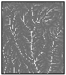
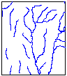 Line coverage
of streams, digitized from blue-lines
on USGS topographic map. Metadata: text
or html
Line coverage
of streams, digitized from blue-lines
on USGS topographic map. Metadata: text
or html
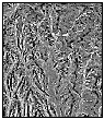
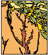 Geology
map, hand digitized from USGS 1:24,000 geological map, 1993. Metadata:
text or html
Geology
map, hand digitized from USGS 1:24,000 geological map, 1993. Metadata:
text or html
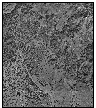 Digital
Orthophotoquad (DOQ) : Aerial photos at a 1-meter resolution, corrected
to show the map view of the landsurface. Metadata: text
or html
Digital
Orthophotoquad (DOQ) : Aerial photos at a 1-meter resolution, corrected
to show the map view of the landsurface. Metadata: text
or html
ELEVATION AND TERRAIN ATTRIBUTE DATA:
 USGS
30m digital elevation model (DEM) of the Los Olivos 7.5min Quadrangle, cropped
to study area. Metadata: text
or html
USGS
30m digital elevation model (DEM) of the Los Olivos 7.5min Quadrangle, cropped
to study area. Metadata: text
or html
Surfaces derived from the USGS DEM:
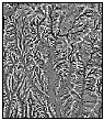
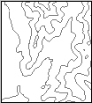 30-meter
contours (close-up shown here). Metadata: text
or html
30-meter
contours (close-up shown here). Metadata: text
or html
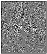
 15-meter
contours (close-up shown here). Metadata: text
or html
15-meter
contours (close-up shown here). Metadata: text
or html
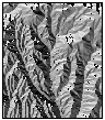
 Slope
grid (degrees). Metadata: text
or html
Slope
grid (degrees). Metadata: text
or html
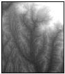
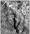
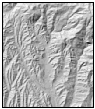 Shaded
relief calculated from the DEM. Metadata: text
or html
Shaded
relief calculated from the DEM. Metadata: text
or html
 Aspect
grid (0-360 degrees). Metadata: text
or html
Aspect
grid (0-360 degrees). Metadata: text
or html
 Curvature
grid. Metadata: text
or html
Curvature
grid. Metadata: text
or html
 Plan
curvature (measured perpendicular to slope, values range from -1 to 1).
Metadata: text or html
Plan
curvature (measured perpendicular to slope, values range from -1 to 1).
Metadata: text or html
 Profile
curvature (measured parallel to slope). Metadata: text
or html
Profile
curvature (measured parallel to slope). Metadata: text
or html
 Terrain
roughness: standard deviation of elevation values calculated per pixel
in a moving circle, radius 300m. Metadata: text
or html
Terrain
roughness: standard deviation of elevation values calculated per pixel
in a moving circle, radius 300m. Metadata: text
or html
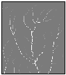 Flow
accumulation: Total number of upslope cells that would theoretically
contribute water to each pixel if water were poured on the surface. Metadata:
text or html
Flow
accumulation: Total number of upslope cells that would theoretically
contribute water to each pixel if water were poured on the surface. Metadata:
text or html
 Flow
direction: Direction water would flow out of each pixel, based on
the elevations of the 8 surrounding cells. Metadata: text
or html
Flow
direction: Direction water would flow out of each pixel, based on
the elevations of the 8 surrounding cells. Metadata: text
or html
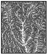
 Upstream
flow path length: number of cells from the nearest ridgeline through
which water would theoretically flow to reach each cell. Metadata:
text or html
Upstream
flow path length: number of cells from the nearest ridgeline through
which water would theoretically flow to reach each cell. Metadata:
text or html
 Compound
Topographic Index (CTI): a wetness index: ln (( upslope contributing
area per unit width orthogonal to the flow direction) / (tan(slope angle) )
. Metadata: text
or html
Compound
Topographic Index (CTI): a wetness index: ln (( upslope contributing
area per unit width orthogonal to the flow direction) / (tan(slope angle) )
. Metadata: text
or html